ST. PETERSBURG, Fla. — Much of the Southeast is dealing with an outbreak of severe weather, including damaging winds and tornadoes, Easter evening.
But will we get any severe weather of our own as we head into the beginning of the week?
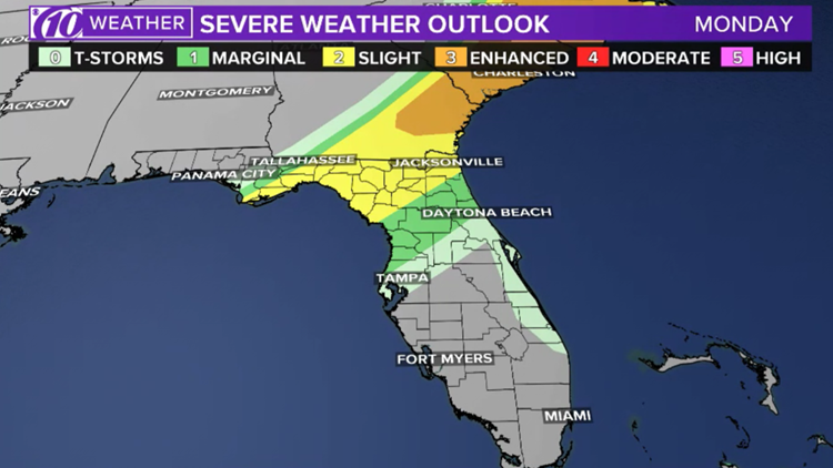
A cold front will push across the Panhandle on Monday and stall just north of the Tampa Bay area. With our unstable atmosphere, there’s a better chance of showers and a strong storm or two to develop in Levy County, but any activity associated with that front will stay well to the north.
The Nature Coast is under a marginal risk of severe weather by the Storm Prediction Center, meaning a strong storm or two tomorrow can’t be ruled out. However, most storms will stay below severe criteria.


With the heat of the day, a storm or two can bubble up in our inland areas, typical with the spring/summertime pattern.
Heading into Wednesday, the stalled front will slowly shift south, providing a better chance for showers and a storm or two to develop that evening throughout the entire Tampa Bay area.
- These essential workers could get $25,000 in hazard pay under 'Hero Fund' plan
- Union: Chief said deputy's coronavirus death caused by homosexual events
- IRS deposits first economic aid payments
- FedEx worker sanitizes package before delivering to immunocompromised home
- Publix employee at South Pasadena store tests positive for coronavirus
- Hotlines, websites offer the latest on COVID-19
FREE 10NEWS APP:


►Stay In the Know! Sign up now for the Brightside Blend Newsletter