ST. PETERSBURG, Fla. — 2020 has been a historic year for many bad -- and some good -- things.
That includes record-breaking weather events like the devastating wildfires on the West Coast of the United States and the packed Atlantic hurricane season on the East Coast.
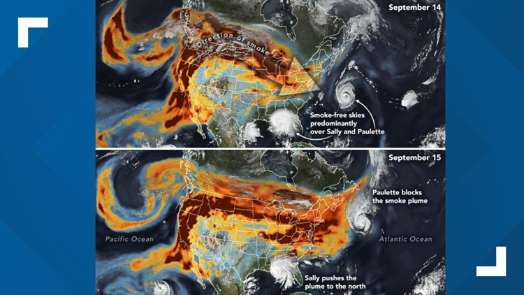
New satellite images and data from NASA's Earth Observatory found that in September, some tropical cyclones collided and helped steer the smoke plumes making their way across the U.S.
The series of images from the agency shows a large swatch of black carbon riding jet stream winds across the country. NASA said Hurricane Paulette's circulating winds in the Atlantic Ocean likely helped block the brunt of the smoke plumes from reaching the East Coast. The same can be said for Hurricane Sally in the Gulf of Mexico, whose winds helped create smoke-free skies around the storm.
However, on Sept. 15-16, the remnants of Paulette had moved northeast and Sally continued to move inland over the Florida Panhandle and Alabama, pushing the plume northward. NASA's images show that by Sept. 16, the black carbon-filled plumes were able to reach the northeast and even beyond into the Atlantic.
"While satellite maps like this show smoke spanning the entire United States, that does not mean the smoke had equally strong effects on air quality at ground level everywhere," NASA's Adam Voiland wrote. "While people living in communities near the fires in California and Oregon faced very unhealthy and hazardous air quality between September 14-16, surface air quality in the eastern U.S. remained mostly good."
NASA said air quality remained good because the smoke was traveling high up in the atmosphere.
On Sept. 14, data from NASA's Micro-Pulse Lidar Network measured smoke at 4-5 miles above Greenbelt, Maryland. A few days later, the plume sank to about 2 miles because of a ridge of high atmospheric pressure.
According to Cal Fire, wildfires have burned an estimated 3.7 million acres and damaged more than 7,000 structures.
Cal Fire also said at least 25 people have died.
Hurricane Sally hit the northern Gulf Coast on Sept. 16, bringing life-threatening flooding as a Category 2 storm at landfall near the Florida-Alabama border. As it weakened, it still brought heavy rain and flooding to eastern Alabama and western Georgia.
- Lightning head into Game 6 looking to become Stanley Cup Champions
- Fire reported at Hard Rock hotel collapse site
- NASA astronaut plans to cast her ballot from International Space Station
- NY Times: Trump paid $750 in US income taxes in 2016,2017
- People with long-lasting COVID-19 symptoms are being diagnosed with other illnesses
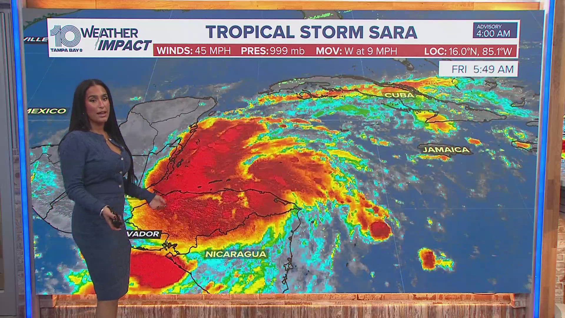
- Tropics 'wake up,' new disturbance to watch
►Breaking news and weather alerts: Get the free 10 Tampa Bay app
►Stay In the Know! Sign up now for the Brightside Blend Newsletter