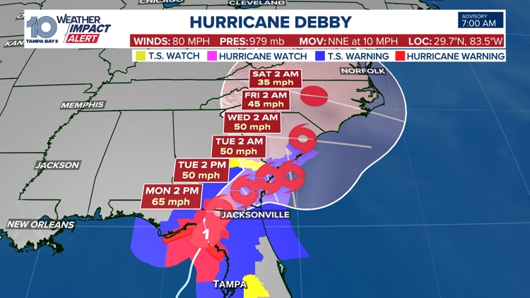
ST. PETERSBURG, Fla. — Hurricane Debby is making landfall along Florida's Big Bend region, not far from where Hurricane Idalia hit in 2023.
Our 10 Tampa Bay weather team says Debby has reached landfall near Jena and Horseshoe Beach. That area is about 20 miles southeast of Keaton Beach, where Idalia made landfall last year.
The National Hurricane Center says Debby made landfall near Steinhatchee, which is just a short distance away from Jena.
Impacts from the hurricane will last into the day Monday, including those from coastal flooding, flash flooding and possible tornadoes.
Hurricane Debby has maximum sustained winds of 80 mph and is located about 5 miles west of Steinhatchee. It is moving to the north at 10 mph, according to the National Hurricane Center's latest update.
Florida's Big Bend and Nature Coast are within the hurricane center's cone of uncertainty, as seen below. However, impacts from a hurricane do occur well outside the cone, and that's expected in Debby's case.
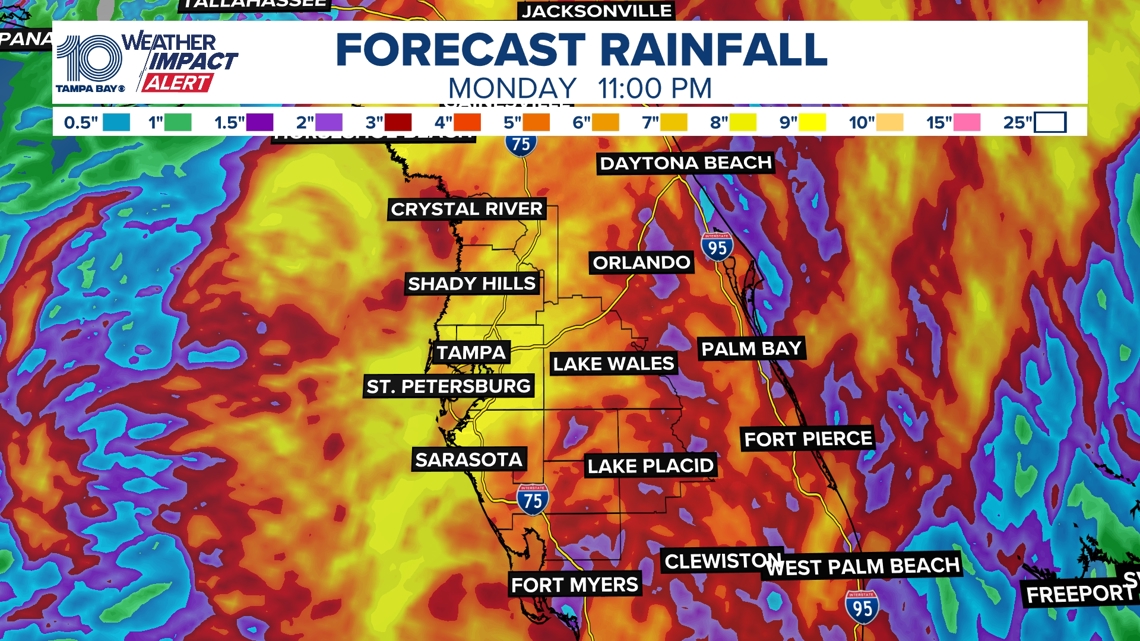
Rainfall totals in the Tampa Bay area are expected to be in the 6-12 inch range, with 18 inches possible.


10 Tampa Bay is keeping you ahead of the storm: Download our free mobile app for real-time storm information and breaking alerts, and download 10 Tampa Bay+ on your favorite streaming device for live updates.
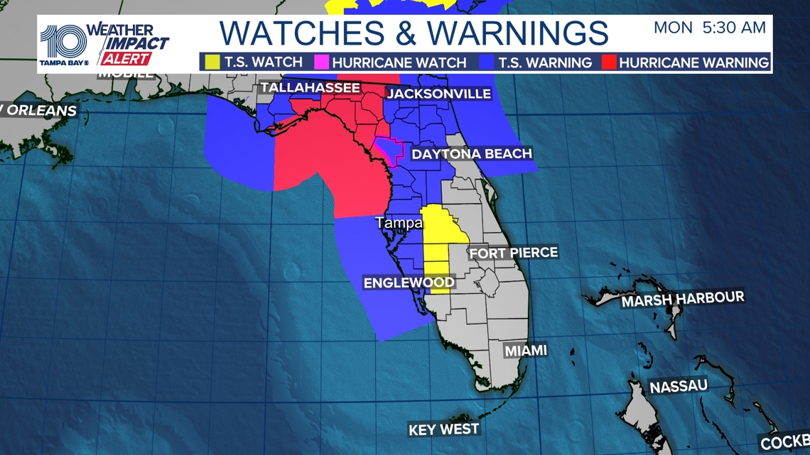
Hurricane, tropical storm advisories:
A storm surge warning, meaning a life-threatening surge is possible within 36 hours, is in effect for the following locations:
- Florida coast from the middle of Longboat Key northward to Indian Pass including Tampa Bay
- Georgia and South Carolina coast from the Mouth of the St. Mary's River to South Santee River South Carolina
A storm surge watch, meaning a life-threatening surge is possible within the next 48 hours, is also in effect for the following locations:
- Florida coast from Englewood northward to the middle of Longboat Key, including Charlotte Harbor
A hurricane warning, meaning hurricane conditions are expected within 36 hours, is in effect for the following locations:
- Florida Gulf coast from Suwannee River to Yankeetown
A hurricane watch, meaning hurricane conditions are possible within 48 hours, is in effect for the following locations:
- Florida coast south of the Suwannee River to Yankeetown
A tropical storm warning, meaning tropical storm conditions are expected within 36 hours, is in effect for the following locations:
- Florida coast south of Yankeetown to Boca Grande
- Florida coast from west of Indian Pass to Mexico Beach
- Ponte Vedra Beach to South Santee River South Carolina

Hurricane impacts
Flooding possible
Heavy rainfall will likely be the most significant impact of Hurricane Debby, with flash and urban flooding possible. The immediate Tampa Bay region is under a moderate risk of flash flooding (a level three out of four) through the next several days.
Rainfall estimates from the American (GFS) and European weather models depict heavy rain along the coastline, with varying amounts inland. In general, it's possible that 6 to 12 inches of rain could fall, with higher amounts especially along the coast and in the immediate Tampa Bay area.

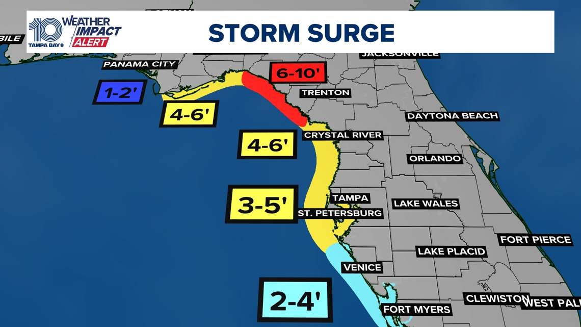
Storm surge threat
A 3-5 foot storm surge is possible from roughly Citrus County southward to Tampa Bay. There is a higher risk for a greater storm surge along Florida's Big Bend and Nature Coast region where Debby is likely to come ashore as a hurricane.
Generally speaking, people along the coast should expect higher-than-normal water levels as this storm approaches.