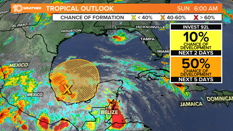
ST. PETERSBURG, Fla. — The National Hurricane Center is watching a new tropical disturbance for possible development of a tropical depression, storm or hurricane. The area of concern is in the southwest Gulf of Mexico.
A trough of low pressure is expected to form over the Bay of Campeche and the southwestern Gulf of Mexico. Feeding off of the warm waters of the Gulf, slow development of this system is possible as it looks to slowly drift north or northwestward.
As of Sunday morning, the National Hurricane Center gives the system a 50-percent chance of development over the next five days. Weather forecast models have been consistent in developing this area of low pressure for the last couple of days.
It is too early to tell who could see the bulk of the impacts from this potential system and what those impacts would be, but everyone along the coast Gulf of Mexico should keep an eye on the latest forecast as this system begins to take shape through next week.
There has already been one named storm this year, a year that is expected to see more activity than normal once again. Tropical Storm Ana developed northeast of Bermuda on May 22 and then dissipated the very next day.
If the system in the southwestern Gulf of Mexico develops into a tropical storm, it will be named Bill.
Tropical storm Ana formed just northeast of Bermuda in late May.
Tropical systems have four stages of development.
- Tropical Disturbance: The birth of a hurricane, having only a slight circulation with no closed isobars around an area of low pressure. Tropical disturbances commonly exist in the tropical trade winds at any one time and are often accompanied by clouds and precipitation.
- Tropical Depression: When the winds reach between 25 and 38 mph, the storm is called a tropical depression. A tropical depression has at least one closed isobar that accompanies a drop in pressure in the center of the storm.
- Tropical Storm: If sustained wind speeds increase to at least 39 mph, a tropical depression is upgraded to a tropical storm. Surface wind speeds vary between 39 and 73 mph and the storm becomes more organized. Tropical storms resemble the appearance of hurricanes due to the intensified circulation.
- Hurricane: A tropical storm becomes a hurricane when sustained wind speeds reach 74 mph. A pronounced rotation develops around the central core as spiral rain bands rotate around the eye of the storm. The heaviest precipitation and strongest winds are associated with the eyewall.
Experts say 2021 is expected to be another busy hurricane season. The NHC predicts 13 to 20 named storms, with 6 to 10 of them hurricanes and 3 to 5 reaching Category 3 strength or higher.
This will be an above-average season for the sixth consecutive year.
Last year, 2020 produced the most named storms ever recorded, with 30.
This broke the previous record of 28 which was set in 2005. Records date back to 1851.
The Atlantic hurricane season runs from June 1 through Nov. 30.
10 Tampa Bay is your Hurricane Headquarters and will continue to keep you updated with the latest forecast and anything else you need to know relating to the tropics.
►Breaking news and weather alerts: Get the free 10 Tampa Bay app
►Stay In the Know! Sign up now for the Brightside Blend Newsletter
.


