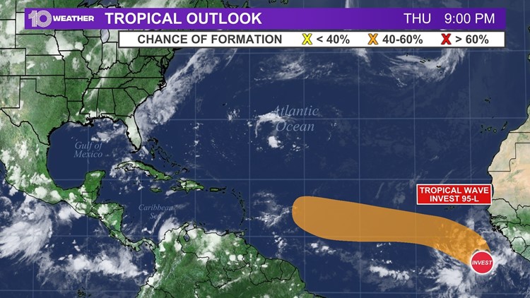
A wave of disturbed weather in the eastern Atlantic Ocean just off the African coast has been designated as Invest 95L by the National Hurricane Center.
This means that the showers and storms gathering in the area will be tracked and watched for tropical development. Hurricane models will be run to help forecast the disturbance's path.
Invest 95L currently has a 20 percent chance of developing into a tropical depression or stronger within the next 48 hours; however, those chances increase to 40 percent for development occurring over the next five days.
The wave will drift west-northwestward before reading the Windward Islands by Monday or Tuesday.
The system will have a lot of work ahead if it wants to strengthen. Relatively cooler ocean waters in its path and some Saharan dust in the wait will make it hard for this to develop.
Most global models don't do much with this system, suggesting that any organization would be limited.
As a result, at this point, Invest 95L isn't expected to be a threat to the United States.
Of course, 10 Tampa Bay will continue to track Invest 95L and the rest of the tropics for you.
For more information on Invest 95L and the rest of the tropics, visit 10TampaBay.com/tropics.
- New video shows Miami high-rise building partially collapse; 1 dead, 35 rescued
- First Lady Jill Biden will attend Lightning vaccination event Thursday in Tampa
- Police: Officer shot in the head in Daytona Beach
- Oath Keeper pleads guilty in Jan. 6 attack; will cooperate
- Catch the Strawberry moon tonight, the last Supermoon of 2021
- A Frank Conversation: New podcast explores race, religion, politics and more
►Breaking news and weather alerts: Get the free 10 Tampa Bay app
►Stay In the Know! Sign up now for the Brightside Blend Newsletter


