
TAMPA, Fla. — Category 4 Hurricane Helene has officially made landfall as of 11:10 p.m. Thursday in Florida's Big Bend, according to NHC.
The eye of the hurricane is currently located just east of the mouth of the Aucilla River, 10 miles west-southwest of Perry, Florida.
The National Hurricane Center has issued hurricane and storm surge warnings for parts of Florida's Gulf Coast, including the Tampa Bay area, ahead of potential impacts from the storm.
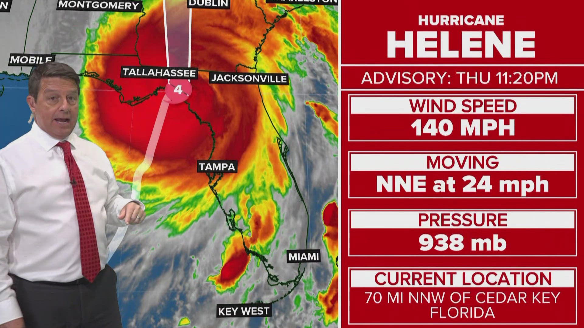
As of the latest advisory, Hurricane Helene is 70 miles north-northwest of Cedar Key and 45 miles east-southeast of Tallahassee. It's moving north-northeast at 24 mph with maximum sustained winds of 140 mph.
Timing: Late Wednesday - early Friday
The Tampa Bay area began experiencing the first rain bands Wednesday night.
Thursday, the system became parallel to Tampa Bay, passing our area and bringing us a surge. Thursday has been the day with the most severe impacts from the storm, with bands of rain and wind. The surge has already gotten underway.
Early Friday, our winds shift out of the southwest as the system leaves our area. Flooding and surge will be the major concern. Conditions return to normal on Saturday with typical showers and heat.
Impacts:
Surge: Citrus, Pasco and Hernando counties could see 6-15 feet. Meanwhile, Hillsborough County could see 5-8 feet while Manatee and Sarasota Counties could see 4-7 feet. Lastly, inland counties like Polk, Hardee, Desoto and Highlands could see 1-3 feet.
Rain: 4-8 inches possible
Wind: 45-55+ mph sustained winds
Severe Weather: Isolated tornadoes possible, a level 1 risk
A storm surge warning has been issued for:
- Mexico Beach eastward and southward to Flamingo
- Tampa Bay
- Charlotte Harbor
A storm surge watch is in effect for West of Indian Pass to Mexico Beach
A hurricane watch has been issued for Englewood to the Anclote River, including Tampa Bay.
A hurricane warning has been issued from Anclote River to Mexico Beach
A tropical storm warning has been issued for:
- The Florida Keys, including the Dry Tortugas
- Flamingo to Anclote River, including Tampa Bay
- West of Mexico Beach to the Okaloosa/Walton County Line
- Flamingo northward to Little River Inlet
- Lake Okeechobee
Now is the time to make sure your hurricane kit is ready and up to date.
10 Tampa Bay is also monitoring a new tropical storm, Tropical Storm Isaac, in the open central subtropical Atlantic. Right now, there are no coastal watches or warnings in effect for that storm. Tropical Storm Isaac is located about 1,345 miles west of the Azores, according to NHC.
We will continue to provide the latest information through your 10 Tampa Bay hurricane headquarters.