As Tropical Storm Eta moves through the Tampa Bay region, it's producing bands of strong wind, flooding rains and even tornado warnings. Here’s what you need to know before you go to bed.
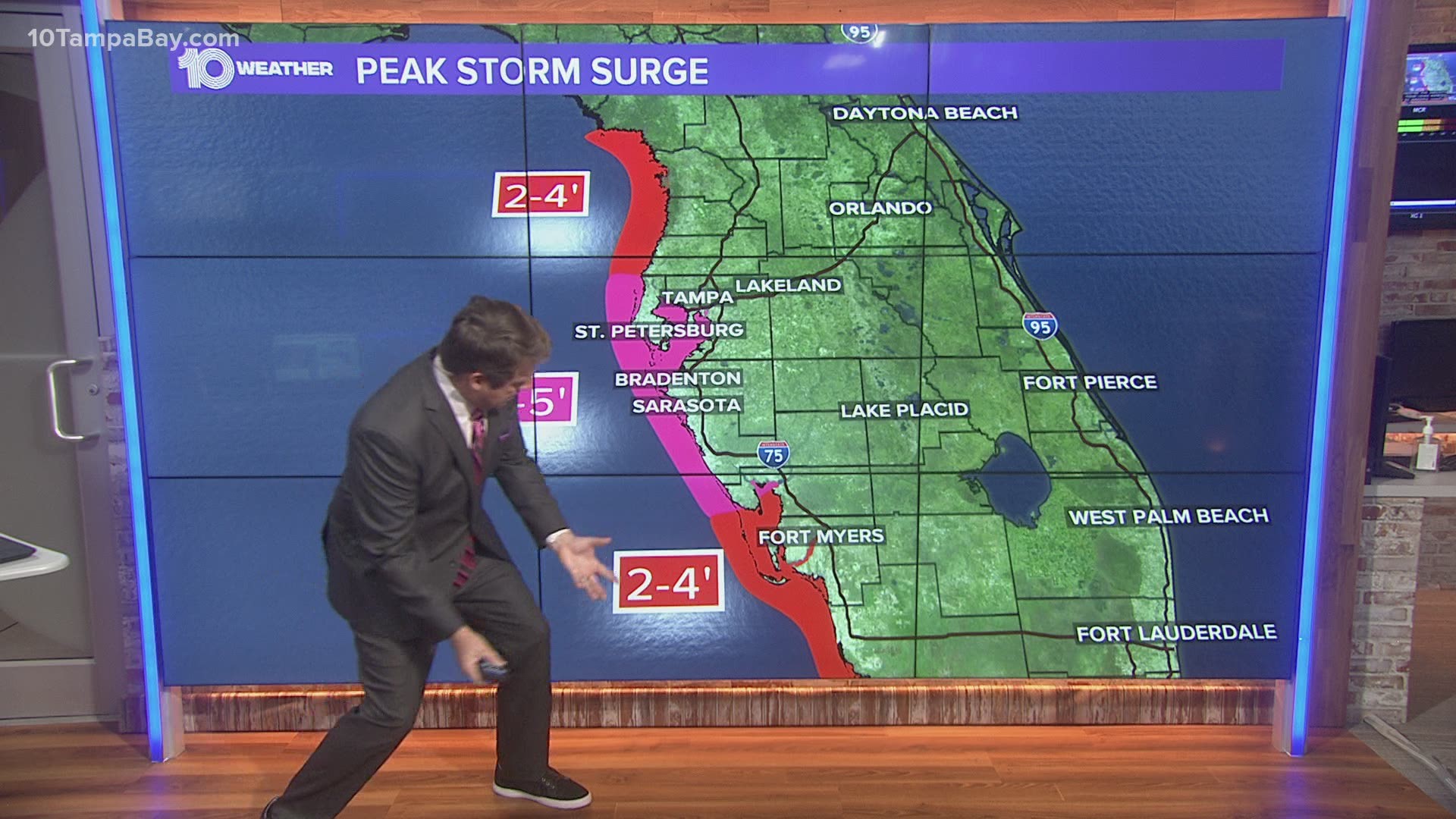
Main concerns: The threat from Tropical Storm Eta will continue across the Tampa Bay Area tonight as the storm moves northward less than 35 miles off the coast of Pinellas Bayway.
Tropical storm force winds (at least 39 mph), localized flash flooding, storm surge, hazardous marine conditions, and perhaps tornadoes will all be possible.
Be very careful tonight and tomorrow if venturing outside as downed power lines may occur.
RELATED: LIVE UPDATES: Tropical Storm Eta continues to drop heavy rain, strong winds across Tampa Bay
Sarasota/Bradenton:
Wind The highest winds will occur through about 10 p.m. and then slowly start to diminish. The highest sustained winds will be about 35-45 mph with gusts to 60 mph.
Storm Surge The storm surge threat of as much as 3-5 feet will occur through about midnight.
Tornado The tornado threat is diminishing throughout the evening and will increasingly diminish as the tropical storm moves north during the evening.
Rain The widespread bands of rain diminish before midnight. Occasional bands of heavy rain will be possible overnight and through the day Thursday.
Flooding Due to 3-5 inches of rain, with some isolated areas of 6-7 inches, some areas of flooding will be possible tonight.
Pinellas/Hillsborough:
Wind The highest winds will occur through about 11 p.m. and then slowly start to diminish.
Storm Surge The storm surge threat of as much as 3-5 feet will occur through about 1 a.m.
Tornado The tornado threat is diminishing throughout the evening and will increasingly diminish as the tropical storm moves north after midnight.
Rain The widespread bands of rain diminish a little after midnight. Occasional bands of heavy rain will be possible overnight and through the day Thursday.
Flooding Due to 3-5 inches of rain, with some isolated areas of 6-7 inches, some areas of flooding will be possible tonight.
Pasco/Hernando/Citrus:
Wind The highest winds will occur through about 2 a.m. and then slowly start to diminish. The highest sustained winds will be about 35-45 mph with gusts to 60 mph.
Storm Surge The storm surge threat of as much as 3-5 feet will occur through about 2-3 a.m.
Tornado The tornado threat will diminish overnight, after about 2 a.m.
Rain The widespread bands of rain diminish a little after midnight. Occasional bands of heavy rain will be possible overnight and through the day Thursday.
Flooding Due to 3-5 inches of rain, with some isolated areas of 6-7 inches, some areas of flooding will be possible tonight.
Polk:
Wind The highest winds will occur through about midnight and then slowly start to diminish. The highest sustained winds will be about 35-45 mph with gusts to 60 mph.
Tornado The tornado threat, mainly across the western part of the county, will diminish overnight, after about 2 a.m.
Rain The widespread bands of rain will continue at times overnight. Occasional bands of heavy rain will be possible through the day Thursday.
Flooding Some isolated flooding can’t ruled out with heavy downpours, but through early Wednesday evening, rain totals have mostly been under an inch.
What other people are reading right now:
- Models predict Tampa Bay could see 15,000 daily COVID-19 cases by January
- Tracking Eta: Tropical Storm Eta forecast to reach hurricane strength today
- Women have served US armed forces since Revolutionary days, but combat ban wasn't lifted until 2013
- 'Several people' taken to the hospital after Tampa shooting, deputies say
- Pfizer says early data signals COVID-19 vaccine is effective
- Santa is still visiting the Tampa Bay area this year
- 2020 Election Results | Get live results from 10 Tampa Bay
►Breaking news and weather alerts: Get the free 10 Tampa Bay app
►Stay In the Know! Sign up now for the Brightside Blend Newsletter

