TAMPA, Fla — A powerful storm system dumped heavy rain on the Tampa Bay area after rolling through Tuesday morning.
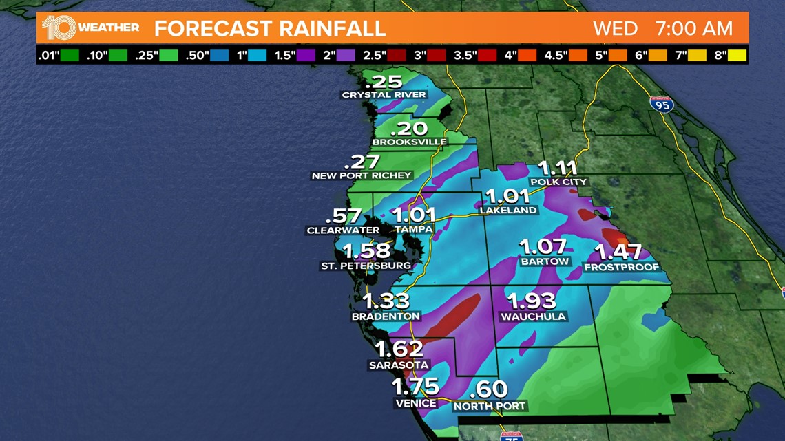
The low-pressure system, which pushed inland from the Gulf of Mexico, brought west-central Florida the most rain it has received in weeks. Depending on where the heaviest showers entered the area, a few spots around town could have picked up 1.5 inches to even 2 inches of rain.


Ahead of the storm, the rain gauge at Tampa International Airport measured only .02 inches of rain so far this December, which is barely a drop in the bucket and about an inch and a half under the month's normal amount.
The dry stretch followed one of the wettest Novembers on record. The month racked up 3.52 inches of precipitation with most of the rain falling in one 24-hour period.
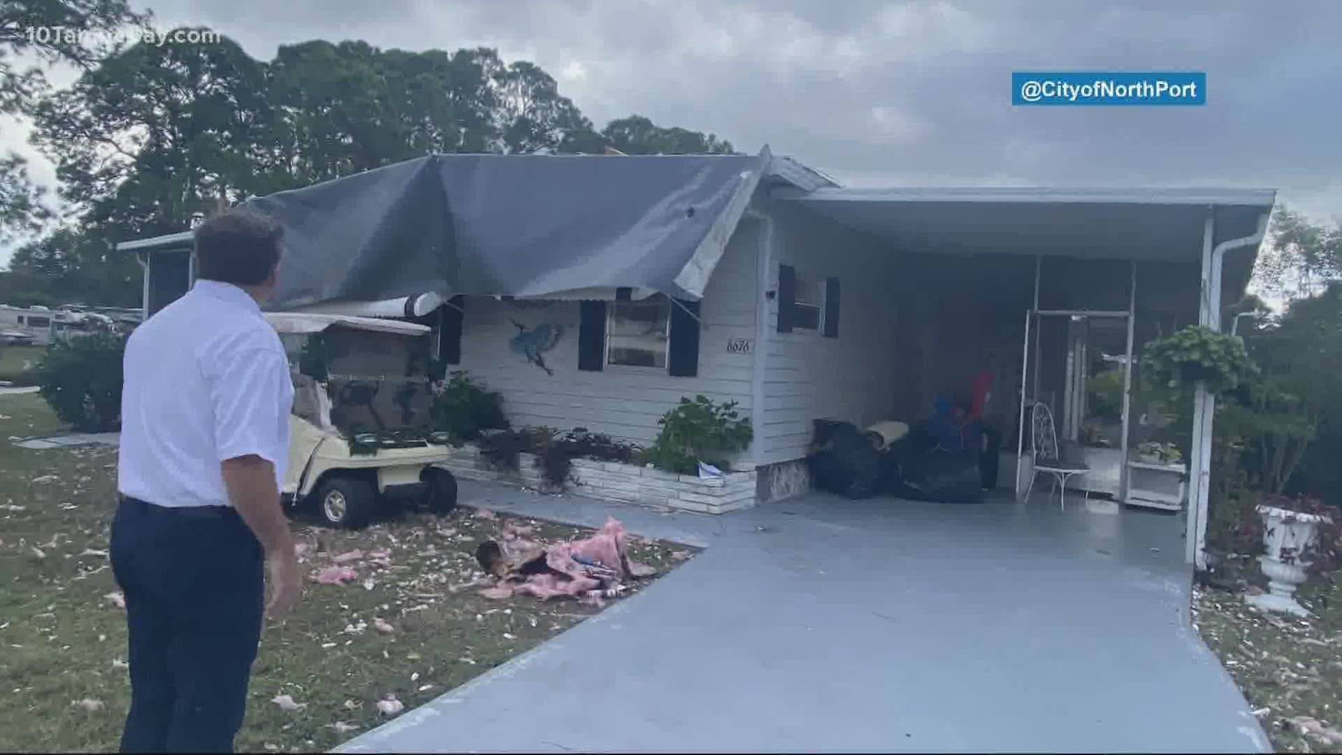
So far, serious storm damage has only been reported at the Holiday Park Community in North Port. According to the city, 15 structures suffered roof damage in the area. The Red Cross is out to help assist those who need it.
"Grateful it wasn’t worse, but we’re glad to be assisting those who need it," the city wrote on Twitter.
Over in Hillsborough County, the sheriff's office said a downed tree temporarily blocked the intersection of South Durant Road and Dover Road.
The City of Venice also had to close Nokomis Avenue at Fiesole Street due to a power line down in the roadway.
"Due to powerful wind gusts, there is debris on many roads. Public Works crews are working on clearing the debris. Please use caution when traveling," a press release reads.
Humphris Park is also closed for the day due to high winds and heavy surf conditions in the area.
A short-lived tornado did touch down around 6:25 a.m. in southwest Florida as an area of low pressure moved onshore, according to the National Weather Service.
The Lee County Sheriff's Office reported damage in the area where photos showed downed trees, debris scattered off roads and a collapsed carport as a result of the storm.
As of 10:50 a.m., TECO reported 59 customers were without power and Duke Energy had outages reaching 950 customers.
As for what comes next? It is the holiday season after all, and the first-day-of-winter storm comes with a present for lovers of cooler temps. The surface low drags a cold front behind it, and that will be the feature that wipes out the unseasonably warm temperatures and humidity.
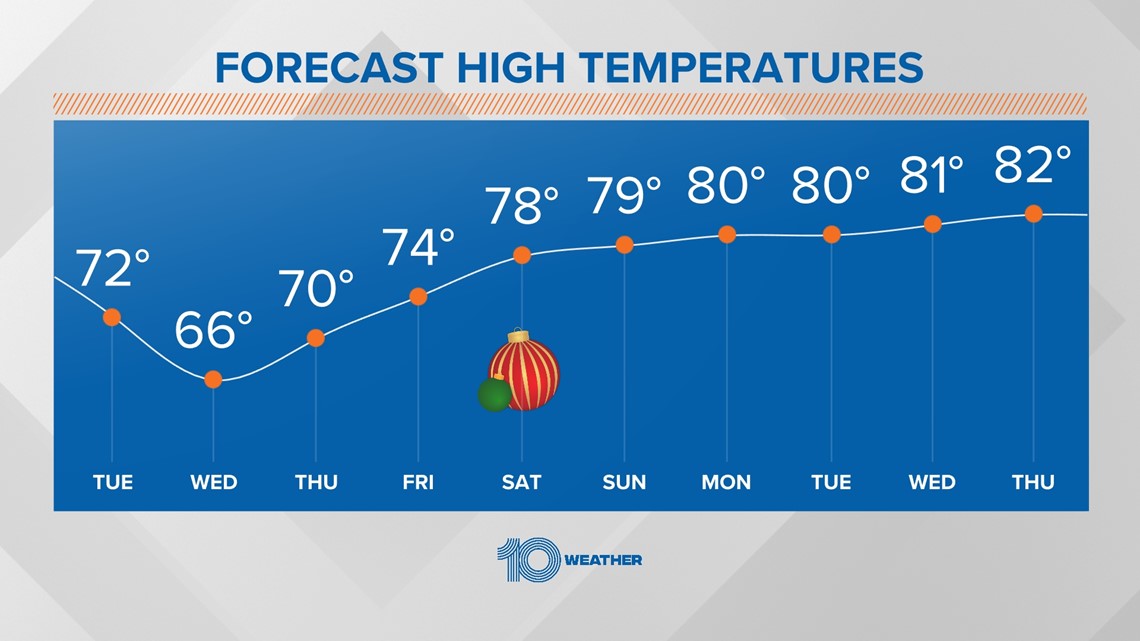
By Wednesday, we will see crisp and cooler air ride in on a gusty northwesterly wind, bringing high temperatures down to the upper-60s and lows to the 50s.
Temperatures rebound quickly after Wednesday, with near to slightly above normal temperatures by Christmas.
Christmas day high temps will be in the mid-70s with clear skies.
---------
Previous story below:
It may seem odd to see such a powerful storm system rolling through the Tampa Bay area at this time of the year... but it's going to happen!
A low-pressure system in the Gulf of Mexico is bringing west-central Florida the most rain it has received in weeks.


Winds pick up (some gusts to near 40 mph) and rain will be steady at times during a soggy morning commute on Tuesday. Depending on where the heaviest showers enter the area, a few spots around town could pick up 1.5 inches to even 2 inches of rain.


As the center of low pressure moves onshore, a few hefty storms are possible. The Storm Prediction Center has placed part of the Tampa Bay area under a Slight "Level 2" risk for severe weather on Tuesday. The threat is low, but a high cape, or lift, could be capable of producing gusty winds, heavy downpours, and an isolated tornado and/or waterspout.
The Tampa Bay area will receive the most rain since the first week of November. The rain gauge at Tampa International Airport measured only .02 inches of rain so far this December, which is barely a drop in the bucket and about an inch and a half under the month's normal amount.
This dry stretch follows one of the wettest Novembers on record. The month racked up 3.52 inches of precipitation with most of the rain falling in one 24-hour period.


It is the holiday season after all, and the first-day-of-winter storm comes with a present for lovers of cooler temps. The surface low drags a cold front behind it, and that will be the feature that wipes out the unseasonably warm temperatures and humidity.
By Wednesday, crisp and cooler air rides in on a gusty northwesterly wind, bringing high temperatures down to the upper-60s and lows to the 50s.
Temperatures rebound quickly after Wednesday, with near to slightly above normal temperatures by Christmas.
Christmas day high temps will be in the mid 70s with clear skies.

