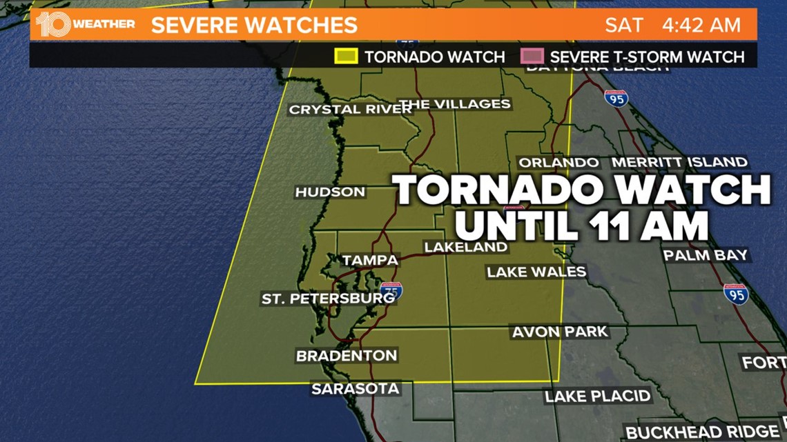
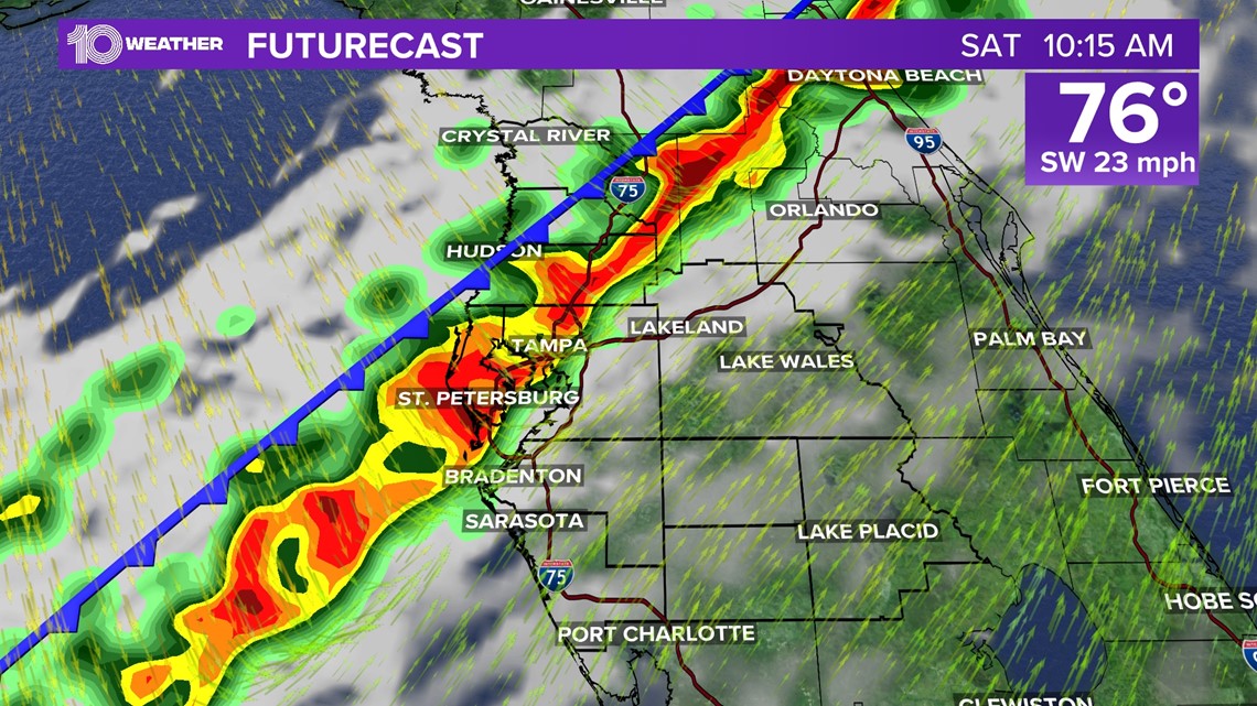
ST. PETERSBURG, Fla. — A potent line of showers and storms rolling in Saturday morning brought the threat of damaging winds and a few tornadoes.
It's for this reason the Storm Prediction Center issued a tornado watch until 11 a.m. for most of the Tampa Bay region.
Latest updates:
10:57 a.m.: Tornado watch canceled for Hillsborough, Pinellas, Polk, Pasco, Manatee and Sarasota counties.
10:15 a.m.: A severe thunderstorm warning is in effect until 11 a.m. for Hardee, Hillsborough, Polk, Manatee, and Sarasota counties.
9:26 a.m.: A severe thunderstorm warning is in effect until 10:15 a.m. for Manatee, Polk, Hillsborough, Pinellas, Sarasota, and Pasco counties. Damaging winds to 60 mph remain the greatest threat.
9:26 a.m.: Tornado watch canceled for Citrus and Hernando counties.
8:45 a.m.: A severe thunderstorm warning is in effect until 9:30 a.m. for Citrus, Hernando, Hillsborough, Pasco, Pinellas and Polk counties. Damaging winds to 60 mph are the greatest threat.
8:36 a.m.: The severe thunderstorm warning continues until 8:45 a.m. for Citrus, Hernando, Pasco and Sumter counties.
8:25 a.m.: The tornado warning has been allowed to expire for Hernando County. Damaging winds remain possible in the area.
8:13 a.m.: A tornado warning is in effect until 8:30 a.m. for western Hernando County. A National Weather Service radar indicated a waterspout just after 8 a.m. located 7 miles offshore, southwest of Weeki Wachee Gardens.
7:55 p.m.: A severe thunderstorm warning is in effect until 8:45 a.m. for parts of Citrus, Hernando, Pasco and Sumter counties. Damaging winds to 60 mph are the greatest threat.

We are still under slight and marginal risks for severe weather on Saturday as a powerful cold front dives in from the northwest. Gusty damaging winds will be the biggest threat with those storms.
Here's what to expect:
Saturday
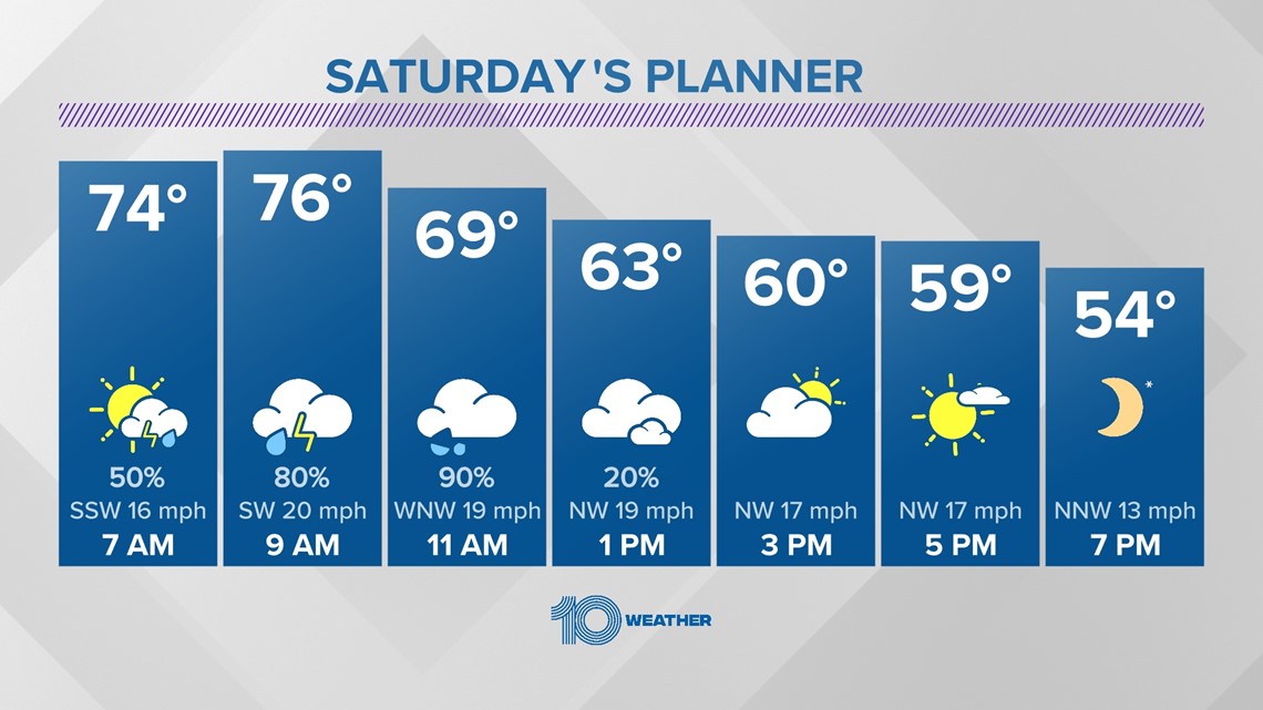
A cold front is expected to rapidly drop into the area from the northwest. Temperatures will start off warm in the 70s Saturday morning, with strong winds out of the southwest.
A line of showers and storms will roll in Saturday morning by the mid-morning hours. Higher severe chances will be possible with this line of storms. A slight risk for severe weather, a level two out of five, has been issued for Hillsborough, Manatee, Polk and Pinellas counties and areas north.
A marginal risk exists for our southern areas.

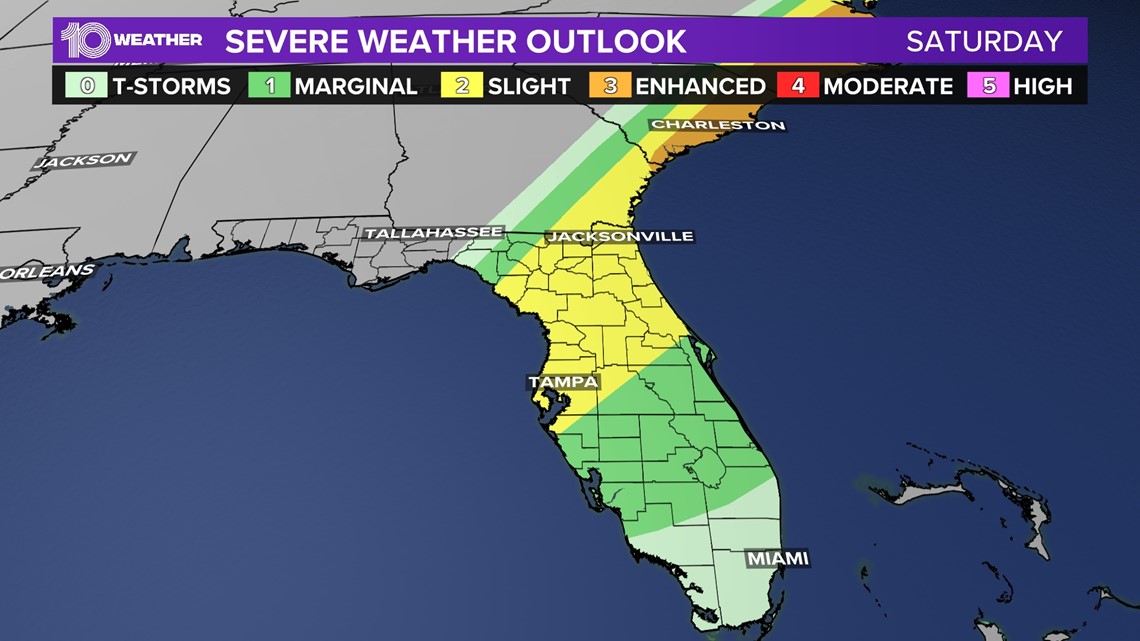
Once again, damaging winds will be the biggest threat, but there will be a low chance for an isolated tornado mainly for areas closer to the Nature Coast. Roughly 7 a.m. to 1 p.m. will be the timeframe for these storms to move in from the northwest to the southeast.

Timeline:
- Storms push in by the mid-morning hours (some strong to severe)
- Heavy rain and storms push east by the early afternoon hours
- Breezy winds from the northwest, gusts up to 40 mph
- Dropping temperatures into the 50s and 60s with clearing skies

What's next?
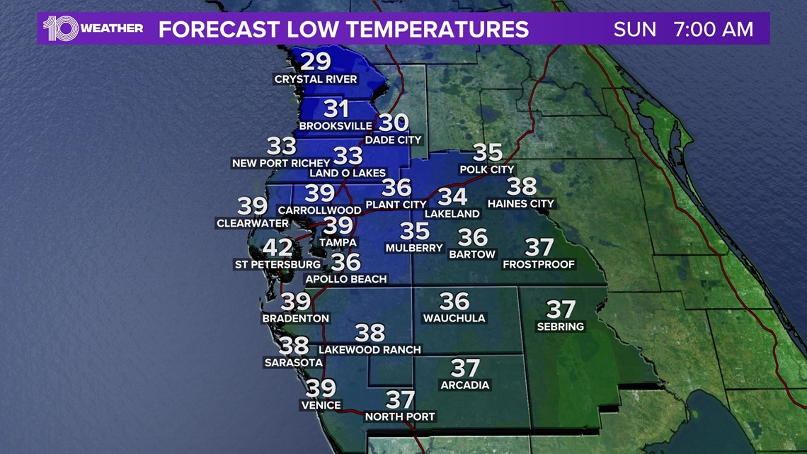
Cold and drier air will drop temperatures Saturday afternoon into the 60s, and eventually into the 50s, with clearing skies as the afternoon evolves. It's going to be a cold night Saturday into Sunday morning with lows in the 30s and 40s!
A breeze will make it feel even a few degrees colder than that. Don't put away the heavy jackets just yet!