ST. PETERSBURG, Fla. — All eyes are on Hurricane Dorian as it remains a powerful storm in the Atlantic Ocean.
The catastrophic made landfall around 12:45 p.m. Sunday in Elbow Cay, Bahamas. Its latest wind speeds now have it Category 1 strength.
10News is your Hurricane Headquarters during Dorian and every storm this season. Keep refreshing this page for the latest updates on Dorian and essential storm-related information across the Tampa Bay region.
Below is our live blog, tracking Hurricane Dorian:
Saturday, Sept. 7
7:15 p.m.
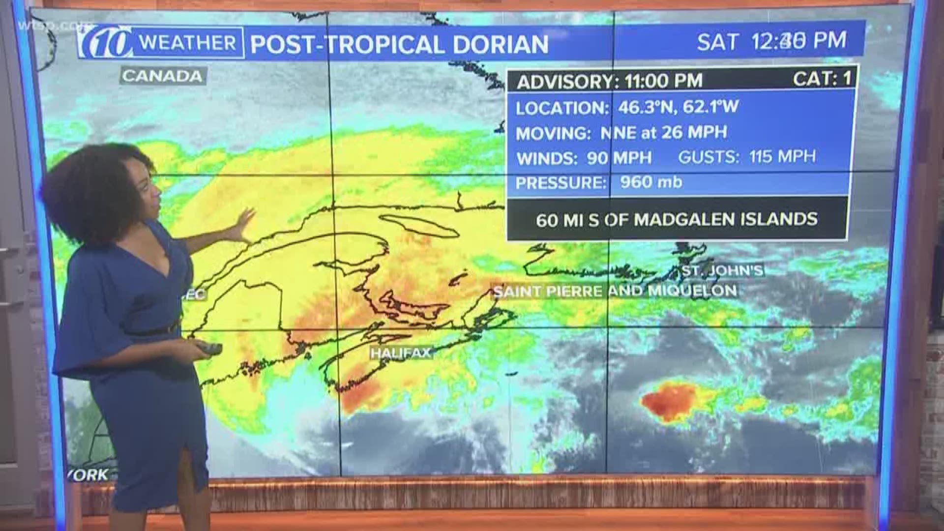
Dorian makes landfall near Sambro Creek in Nova Scotia, Canada.
5 p.m.
Dorian becomes a hurricane-force post-tropical cyclone as it moves closer to Nova Scotia.
Friday, Sept. 6
5: p.m.
Hurricane Dorian has started to move away from the mid-Atlantic U.S. The storm is expected to bring hurricane-force winds to parts of Nova Scotia.
2 p.m.
The Canadian Hurricane Center is issuing warnings, as Hurricane Dorian continues to churn to the northeast.
Dorian is currently packing 90 mph winds, as it moves along at 21 mph. The latest data shows the eye about 125 miles northeast of Cape Hatteras, North Carolina.
11 a.m.
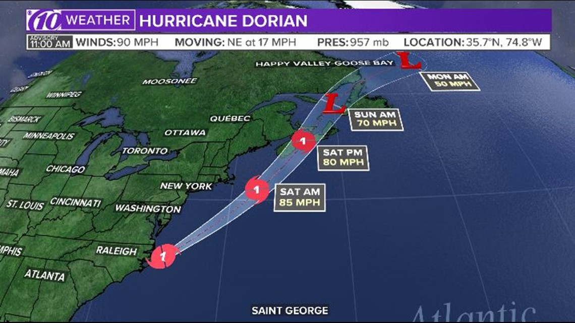
Hurricane Dorian's eye is moving over the Atlantic Ocean, east of the North Carolina coast. As of 11 a.m., the eye was located about 50 miles northeast of Cape Hatteras, North Carolina. Maximum sustained winds are 90 mph. Dorian is currently moving to the northeast at 17 mph. A tropical storm warning has been issued east of Bar Harbor, Maine, to Eastport, Maine.

9:10 a.m.
Hurricane Dorian has come ashore at Cape Hatteras on North Carolina's Outer Banks, marking its first U.S. landfall since it slammed into the Bahamas days ago.
Dorian sideswiped most of the Southeast seaboard from Florida to Carolinas in recent days before its eye made landfall Friday morning.
At 9 a.m. EDT, the storm's center was moving northeast at 14 mph (22 kph).
8 a.m.
Dorian howled over North Carolina's Outer Banks on Friday, lashing the low-lying barrier islands as a weakened Category 1 hurricane.
Dorian's eye was 10 miles off Cape Hatteras, North Carolina, as the storm moved northeast at 14 mph. It's expected to remain a hurricane as it sweeps up the Eastern Seaboard Friday and Saturday, lashing the New England shore with heavy surf.
5:30 a.m.
The U.S. National Hurricane Center in Miami is reporting hurricane-force wind gusts along the southern Outer Banks of North Carolina.
A weather station at Cape Lookout on the southern end of the chain of low-lying islands recently reported a 10-minute average wind of 63 mph, equivalent to a 1-minute sustained wind speed of 69 mph.
A wind gust of 75 mph was also reported, but the weather station inside the western part of Dorian's eye hasn't reported data since 3 a.m.
Dorian's center is around 15 miles south of Cape Lookout, and around 80 miles southwest of Cape Hatteras, further north on the string of barrier islands and spits.
The Category 1 storm's top sustained winds remain at 90 mph and the storm is still moving northeast at 14 mph.
The storm is being blamed for at 30 deaths.
Thursday, Sept. 5
11 p.m.
The core of Hurricane Dorian was brushing North Carolina's coast Thursday night. The storm had maximum sustained winds of 100 mph. Hurricane Dorian remains a Category 2 Hurricane as it lashes beats the Carolinas' coastline.
5 p.m.:
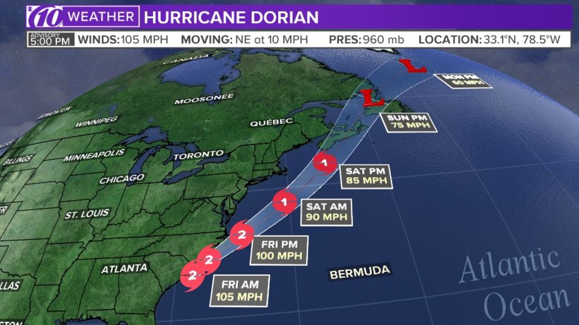
Hurricane Dorian's winds have decreased to 105 mph as it moves at 10 mph. The slightly downgraded Category 2 storm is currently about 85 miles south-southwest of Wilmington, NC.

2 p.m.:
Hurricane Dorian's wind speeds remain at 110 mph as it continues to move along the east coast at 8 mph, staying just offshore. The Category 2 storm is currently about 115 miles south-southwest of Wilmington, N.C.
1 p.m.:
An SUV got stuck in the water on Myrtle Beach, South Carolina, as Hurricane Dorian churned off the coast.
11:00 a.m. update:
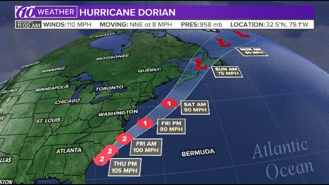
Hurricane Dorian's wind speeds have decreased to 110 mph, now making it a Category 2 storm. Dorian's eyewall is about 50 miles east-southeast of Charleston, South Carolina.
The tropical storm warning has been extended north to Fenwick Island, Delaware and also north in the Chesapeake Bay to Drum Point, including the Tidal Potomac River south fo Cobb Island.

8:15 a.m. update:
Hurricane Dorian remains a Category 3 storm with winds ups to 115 mph.
Constant, howling winds from Dorian are blowing through downtown Charleston, South Carolina as the hurricane blows off the coast of the Carolinas. Hurricane-force winds are remaining just offshore but tropical storm-force winds are whipping around and rattling the windows of a 14-floor hotel on the Ashley River. The National Hurricane Center says the Category 3 storm is about 80 miles south-southeast of Charleston .
Hundreds of shelter animals from coastal South Carolina have arrived in Delaware ahead of Hurricane Dorian's expected landfall.
6 a.m. update:
The News Journal of Wilmington reports the animals were moved from shelters at risk of flooding. The Category 3 storm began making its way across the Carolinas Thursday and was expected to flood low-lying areas and bring enough rain to cause flash flooding concerns well inland.
Nearly 200 animals were airlifted off the endangered coast and picked up by Brandywine Valley SPCA early Tuesday. About 150 other animals were expected to arrive that night via land transport from Best Friends Animal Society. The animals may be up for adoption throughout New England later this week.
Brandywine says the lessened South Carolina shelter populations will make space for local pets impacted by Dorian.
Wednesday, Sept. 4
11 p.m.
Hurricane Dorian strengthened into a major Category 3 hurricane Wednesday night. The storm had sustained winds of 115 mph, according to the NHC's 11 p.m. update.
All watches and warnings for the east coast of Florida south of the Mouth of St. Mary's River have been discontinued.
8 p.m.
Hurricane Dorian continues to move up the east coast of the U.S. with maximum sustained winds of 110 mph.
The total number of deaths in the Bahamas jumped from 7 to 20 people.
5 p.m.
An Air Force hurricane hunter aircraft confirms Hurricane Dorian has strengthened slightly, as its eye moves east of the coast of southeastern Georgia.
Storm surge and tropical storm warnings have been extended further north. It's currently about 150 miles south of Charleston, South Carolina.

3:30 p.m.
Around 360,000 people have evacuated from the South Carolina coast so far due to Hurricane Dorian. South Carolina Gov. Henry McMaster is once again pleading for anyone who hasn't evacuated the coast to leave now, as Hurricane Dorian is expected to bring possibly hurricane-force winds to the area Thursday.
2 p.m.
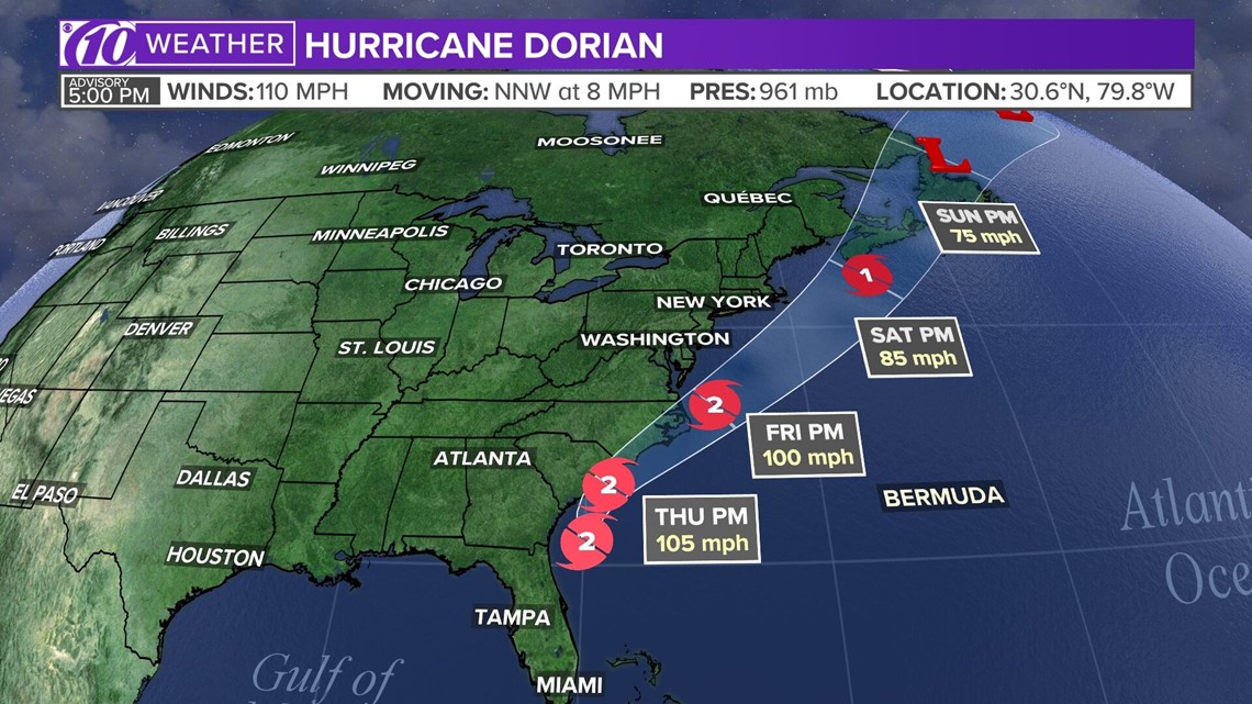
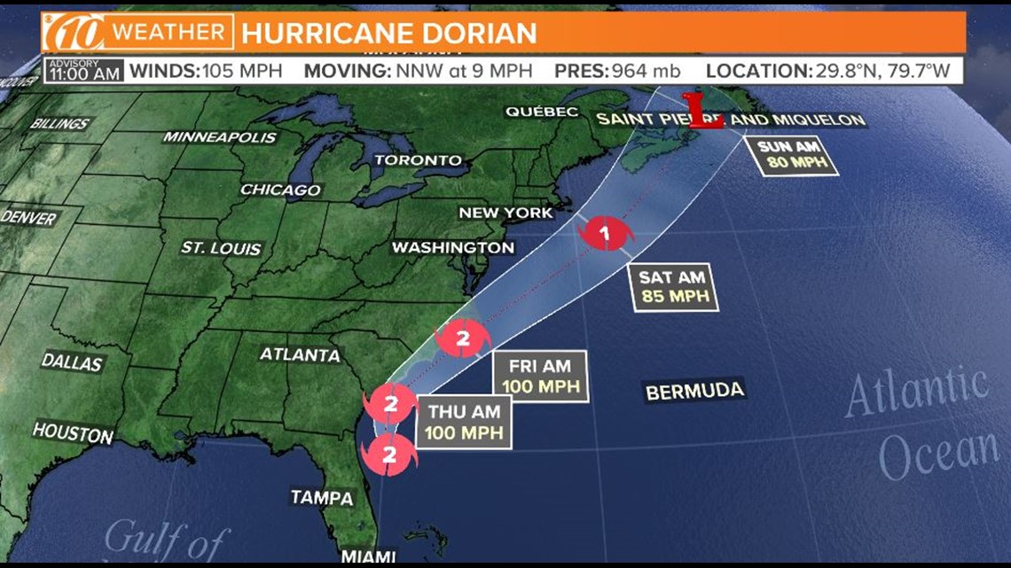
Hurricane Dorian is now about 115 miles east of Jacksonville, Florida. It's moving to the north-northwest at 9 mph and packing 105-mph winds.
Dorian is still a Category 2 storm.

11 a.m.
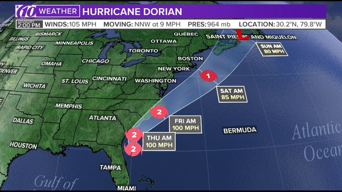
Hurricane warnings are being extended northeastward along the coast of North Carolina, as Dorian continues moving parallel to Florida's northeast coast.
Maximum sustained winds are 105 mph, and the storm is moving north-northwest at 9 mph. It's currently about 90 miles east-northeast of Daytona Beach, Florida.

Updated advisories:
Storm Surge Warning:
- North of Port Canaveral, Florida to the North Carolina/Virginia border
- Pamlico and Albemarle Sounds
- Neuse and Pamlico Rivers
Storm Surge Watch:
- North Carolina/Virginia border to Poquoson, Virginia, including Hampton Roads
Hurricane Warning:
- North of Savannah River to the North Carolina/Virginia border
- Albemarle and Pamlico Sounds
Hurricane Watch:
- North of Ponte Vedra Beach, Florida to Savannah River
Tropical Storm Warning:
- Volusia/Brevard County, Florida line to Savannah River
Tropical Storm Watch:
- The North Carolina/Virginia border to Chincoteague, Virginia
- Chesapeake Bay from Smith Point southward


8 a.m.
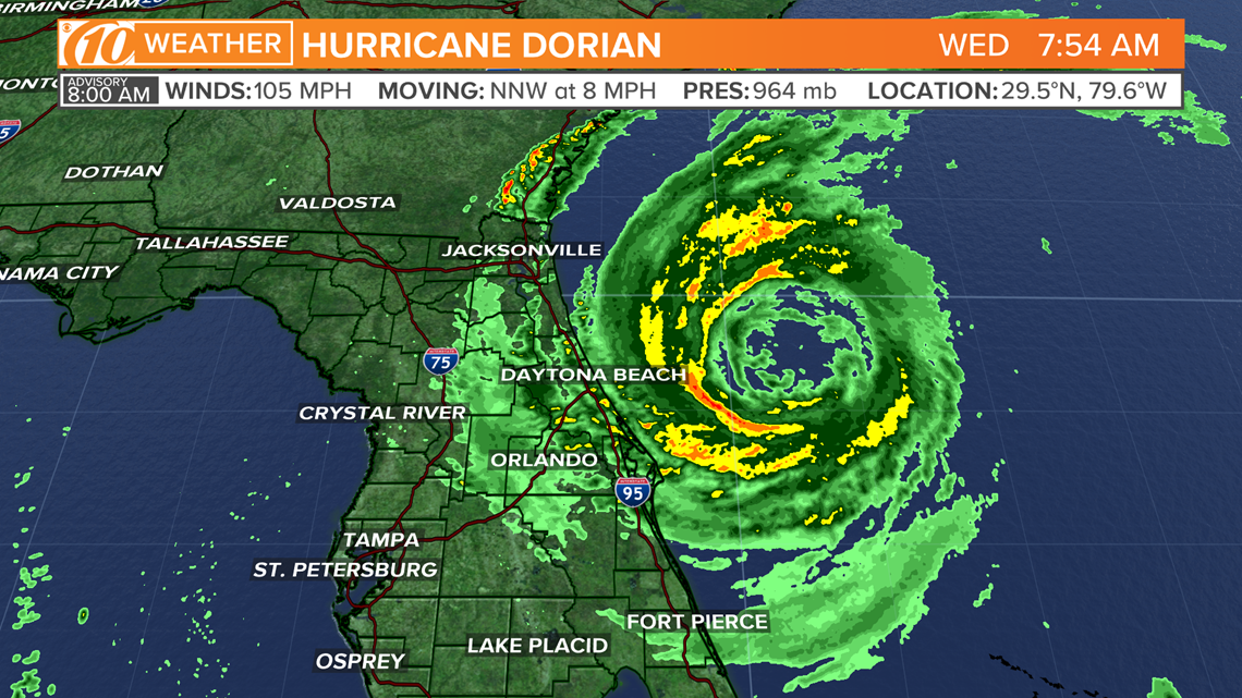
Hurricane Dorian is about 95 miles east-northeast of Daytona Beach, Florida and about 135 miles east-southeast of Jacksonville. Its maximum sustained winds are at 105 mph.
The storm is moving north-northwest at 8 mph. The minimum central pressure is at 964 mb.
Previous warnings and watches have not changed since the 5 a.m. advisory.
The National Hurricane Center said Dorian's eye is forecast to move dangerously close to Florida's east coast and the Georgia coast through Wednesday evening. The eye is expected to move near or over the coast of South Carolina and North Carolina Thursday through Friday morning.

7:20 a.m.
As of Wednesday morning, 19,271 people around Florida were reporting power outages.
The counties reporting the highest number of power outages are Brevard, Duval, Orange, St. Johns and Volusia.
Volusia County was reporting the most people without power: 6,862.
The Brevard County emergency operations center also said the county's hurricane warning was downgraded to a tropical storm warning.
5 a.m.
Bahamians are rescuing victims of Hurricane Dorian with jet skis and a bulldozer as the U.S. Coast Guard, Britain's Royal Navy and a handful of aid groups try to get food and medicine to survivors.
Airports are flooded and roads impassable after the most powerful storm to hit the Bahamas in recorded history parked over Abaco and Grand Bahama islands and pounded them with winds up to 185 mph (295 kph) and torrential rain before finally moving into open waters on a course toward Florida.
People on the U.S. coast are making final preparations for a storm with winds at a still-dangerous 110 mph (175 kph).
At least seven deaths have been reported in the Bahamas, with the full scope of the disaster still unknown.
TUESDAY, SEPT. 3
11 p.m. update:
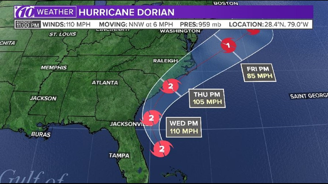
Dorian remains a Category 2 storm with maximum sustained winds of 110 mph. As of the latest National Hurricane Center update, Dorian was located about 95 miles east of Cape Canaveral, Florida. It's moving to the northwest at 6 mph.

10:52 p.m. update:
Three major cruise lines that sail to the Bahamas have pledged their support for Hurricane Dorian relief and recovery efforts.
As the storm slowed to a crawl over the Bahamas, its relentless winds caused catastrophic damage and flooding. As of Tuesday, the death toll in the Bahamas had risen to seven and is expected to go even higher.
Relief officials have reported scenes of utter ruin is some areas.
Royal Caribbean said it would be committing $1 million to Dorian disaster relief, and ITM - its partner in a joint venture developing the Grand Lucayan Resort in Freeport - is also donating an additional $100,000.
10:43 p.m. update:
Hurricane Dorian rescue and recovery efforts are well underway after the Bahamas were devastated by the powerful storm.
As of Tuesday, members of the Coast Guard rescued 47 people from the islands. Crew members continue to conduct air operations based out of Andros Islands in the Bahamas.
9:20 p.m. update:
The prime minister of the Bahamas said parts of his country, which is just 200 miles southeast of Florida, were in "the midst of a historic tragedy." Hurricane Dorian was stuck in place over the island nation, pounding the northern Bahamas for nearly 48 hours.
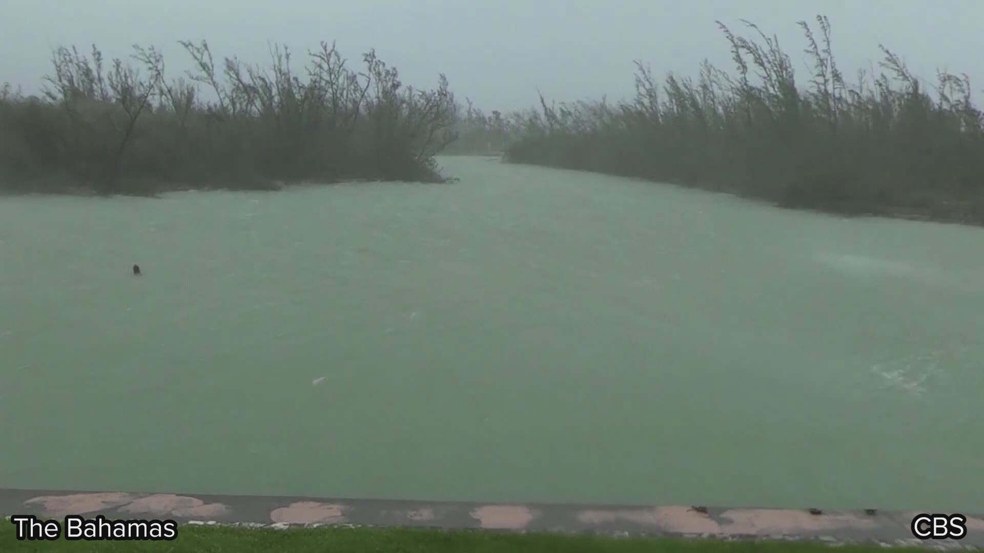
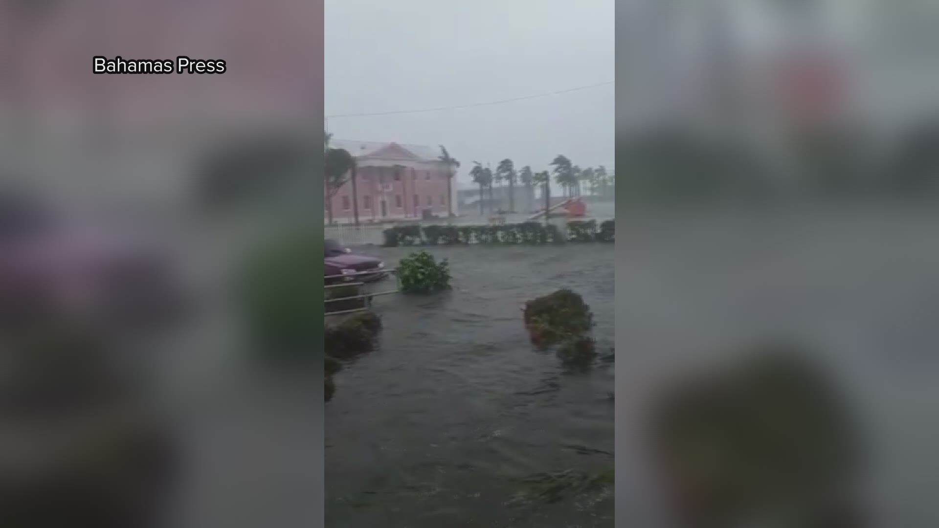
Reports from the country were dire – and the pictures tell the catastrophic story.
-CBS News
8 p.m. update:
The outer bands of Hurricane Dorian are rolling in across Florida's east coast, battering the region with winds of at least tropical storm force.
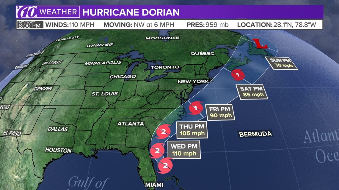
Dorian is a Category 2 storm with maximum sustained winds of 110 mph. As of the latest National Hurricane Center update, Dorian was located about 110 miles east of Cape Canaveral, Florida. It's moving to the northwest at 6 mph.

6:38 p.m. update:
Disney has committed to donating $1 million to relief and recovery efforts to non-profit agencies helping those affected by Hurricane Dorian.
The donation will go toward providing recovery and rebuilding efforts in the affected areas of the Bahamas. As well as to provide supplies, food and construction material for those affected, according to a release on their website.
“We hope our $1 million donation will provide much-needed relief and help our neighbors, colleagues, and all those impacted by this devastating storm begin the long process of recovery as they work to put their lives and communities back together,” said Robert A. Iger, Chairman and CEO of Walt Disney.
The release says the cruise, Disney Castaway Cay, employs over 60 Bahamians from Abaco and Grand Bahama and several others from the Bahamian Islands. According to the release, Disney employees affected “will have access to a range of resources.”
5 p.m. update:
Hurricane watches and warnings have been expanded along the U.S. southeast coast as Hurricane Dorian finally makes a move on away from the Bahamas.
Dangerous winds and life-threatening storm surge will continue through this evening and into the day Wednesday.
Dorian is a Category 2 storm with maximum sustained winds of 110 mph. As of the latest National Hurricane Center update, Dorian was located about 105 miles east of Vero Beach, Florida. It's moving to the northwest at 6 mph.

4:09 p.m. update:
A pilot surveys flooding and damage in the Bahamas' Abaco Islands after Hurricane Dorian ravaged the island nation.
3:50 p.m. update:
This heart-wrenching photo shows Julia Aylen wading through waist-deep water carrying her pet dogs as she is rescued from her flooded home during Hurricane Dorian in the Bahamas.
The hurricane devastated thousands of homes, trapped people in attics and crippled hospitals.
RELATED: Video from Bahamas storm zone shows widespread destruction as Coast Guard begins recovery efforts


3:45 p.m. update:
Walt Disney World will resume operations across its parks and attractions Wednesday, Sept. 4. They include:
- Magic Kingdom Park: 8 a.m. to 10 p.m.
- Epcot: 9 a.m. to 9 p.m.
- Disney's Hollywood Studios: 9 a.m. to 10 p.m.
- Disney's Animal Kingdom: 8 a.m. to 9 p.m.
- Disney's Blizzard Beach Water Park: Closed
2 p.m. update:
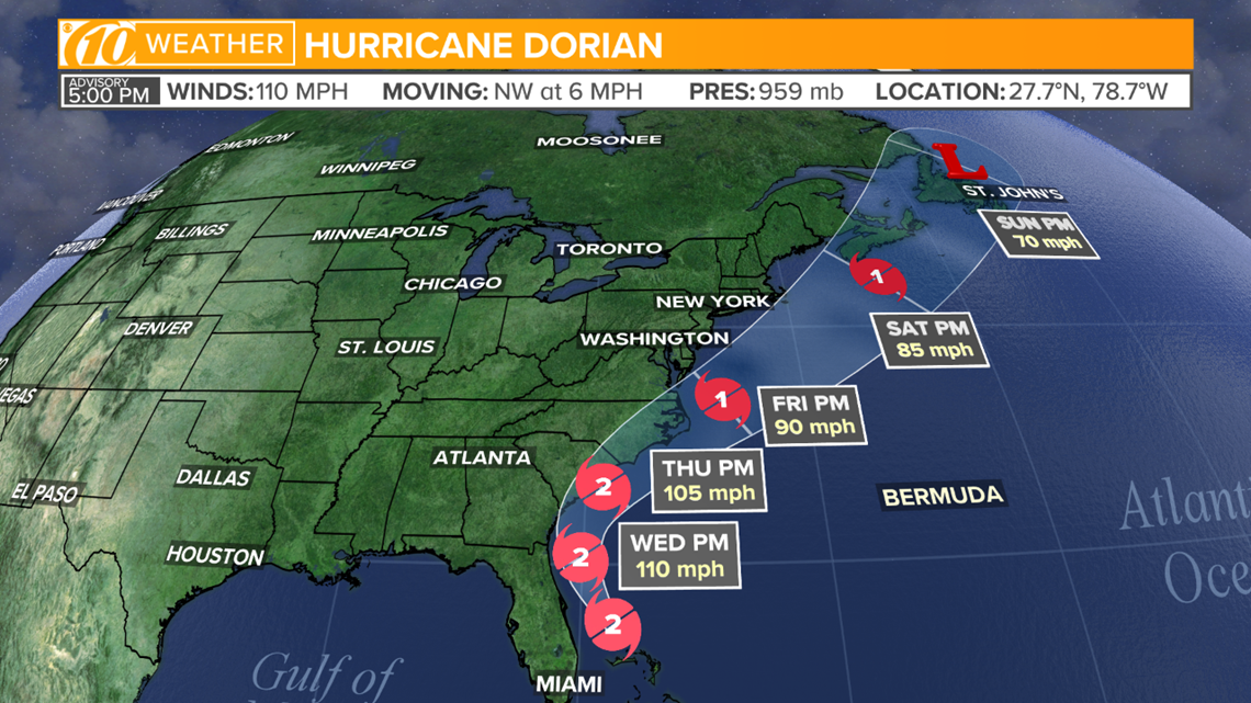
Hurricane Dorrian's winds are holding at 110 mph as the storm continues to move closer to the Florida coast. The National Hurricane Center said the storm is now 65 miles north of Grand Bahama and 105 miles east of Fort Pierce, Florida. Dorian is moving northwest at about 5 mph.
The storm is finally moving away from the Bahamas, so the warning in the Bahamas has been downgraded from a Hurricane Warning to a Tropical Storm Warning. Other warnings remain in effect. They are as follows:
- Storm Surge Warning from Jupiter Inlet, Florida to South Santee River, South Carolina.
- Storm Surge Watch north of South Santee River, South Carolina, to Cape Lookout, North Carolina.
- Hurricane Warning for Jupiter Inlet, Florida, to Ponte Vedra Beach, Florida, and north of Edisto Beach, South Carolina, to South Santee River, South Carolina.
A Hurricane Watch is in effect for North of Ponte Vedra Beach, Florida, to Edisto Beach, South Carolina, north of South Santee River, South Carolina, to Duck North Carolina and Albemarle and Pamlico Sounds.
A Tropical Storm Warning is in effect for Grand Bahama and the Abacos Islands in the northwestern Bahamas, north of Deerfield Beach, Florida, to Jupiter Inlet, Florida, and north of Ponte Vedra Beach, Florida, to Edisto Beach South Carolina.
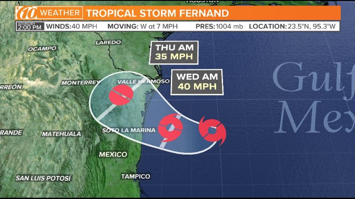
In addition to Dorian, a new tropical storm has formed in the Gulf of Mexico.

12 p.m. update
Hurricane Dorian continues to creep away from the Bahamas toward the east coast of Florida as a Category 2 hurricane.
As it departs, we are starting to see the damage and flooding Dorian left in its path after sitting over the islands for more than a day.
Now that the storm is moving again, the National Hurricane Center is getting a better idea of when it will hit the east coast of Florida and the rest of the U.S.
Florida is expected to see tropical-force winds Tuesday night with the storm sliding up the coast from there.
11 a.m. update:
Hurricane Dorian is now a Category 2 storm with winds at 110 mph. The storm is moving northwest at about 2 mph.
The storm is about 45 miles north of Freeport, Grand Bahama and 105 miles east of Fort Pierce, Florida.
- A storm surge warning has been extended northward to South Santee River, South Carolina and a storm surge watch was extended northward to Cape Lookout, North Carolina.
- A hurricane warning was issued for the coast of South Carolina from north of Edisto Beach to the South Santee River.
- A hurricane watch has been issued from north of South Santee River to Duck, North Carolina, including the Pamlico and Albermarle Sounds.
- A tropical storm warning was extended north to Edisto Beach, South Carolina.
- A storm surge warning has been discontinued south of Jupiter Inlet, Florida.
- A storm surge watch has been discontinued south of Lantana, Florida.
- A hurricane watch from Deerfield Beach to Jupiter Inlet has been discontinued.
- A tropical storm watch form Golden Beach to Deerfield Beach has been discontinued.
8 a.m. update:
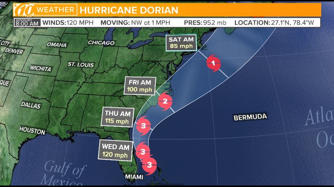
The National Hurricane Center's latest update shows Hurricane Dorian's track shifting away from Florida, but hugging the east coast -- where it could still bring major impacts to Florida and other states.
As of 8 a.m., Dorian's eye was beginning to inch toward the northwest. But, its southern eyewall is still pounding Grand Bahama with maximum sustained winds of 120 mph and higher gusts.

6 a.m. update:
The following watches and warnings are in effect:
- Hurricane warning: Grand Bahama and the Abacos Islands in the northwestern Bahamas, Jupiter Inlet to Ponte Vedra Beach
- Hurricane watch: North of Deerfield Beach to Jupiter Inlet, Flagler/North of Ponte Vedra Beach to South Santee River, SC
- Tropical storm warning: North of Deerfield Beach to Jupiter Inlet, north of Ponte Vedra Beach to Altamaha Sound Georgia
- Tropical storm watch: North of Golden Beach to Deerfield Beach, Lake Okeechobee
- Storm surge warning: Lantana to Savannah River
- Storm surge watch: North of Deerfield Beach to south of Lantana, Savannah River to South Santee River, SC
5 a.m. update:
Winds and rain from Hurricane Dorian continue to pound the northwest Bahamas, sending people fleeing the floodwaters from one shelter to another. The hurricane has weakened to a Category 3, with top sustained winds dipping to 120 mph. Dorian is almost stationary, centered about 25 miles northeast of Freeport. That's roughly the same distance from the city it was Monday morning.
3 a.m. update
The devastating Category 3 hurricane remains at a standstill in the northwestern Bahamas. Wind speeds are sustained at 120 mph with gusts up to 150 mph. The storm is about 100 miles east of West Palm Beach. Northerly movement is expected to begin today.
MONDAY, SEPT. 2
►Stay informed with all tropical weather: Check out our must-have interactive Hurricane Headquarters guide here.
11 p.m. update:
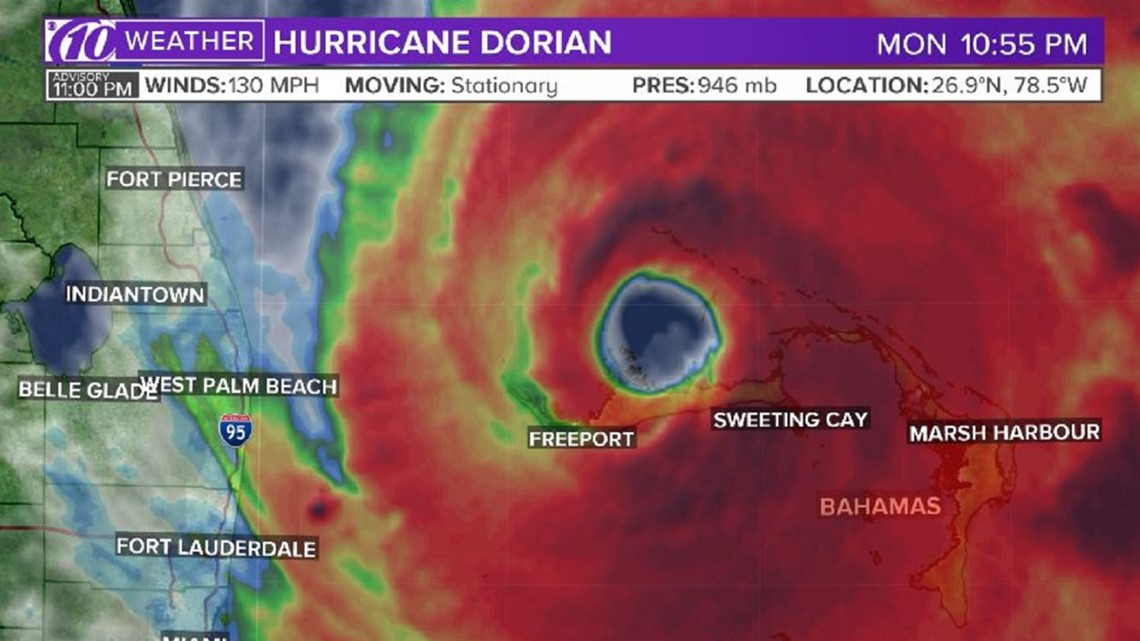
People in parts of the northern Bahamas have been experiencing this for, quite literally, hours -- nonstop: storm surge up to roofs and winds of at least an EF-2 tornado.
Hurricane Dorian remains stationary as it continues its hours-long assault on the islands. The Category 4 hurricane is about 30 miles north-northeast of Freeport and roughly 100 miles east of West Palm Beach, Florida, according to the National Hurricane Center's latest advisory.
The storm is producing maximum sustained winds up to 130 mph as it just barely remains a Category 4 storm.

9:47 p.m. update:
The Coast Guard from Air Station Clearwater deployed a number of assets and crews to help with Hurricane Dorian recovery efforts in the Bahamas.
MH-60 Jayhawk helicopters were used along with health service technicians on Andros Island as a rapid-response team.
The crew members announced they were successful in rescuing 19 people Monday from the Marsh Harbour Clinic to the Nassau International Airport.
In total, four Jayhawk aircrews finished five medical evacuations with people ranging from children to the elderly in different medical conditions.


9:28 p.m. update:
The Air Force Reserve Hurricane Hunters tweeted video Monday of their 10-hour mission inside Hurricane Dorian as it hammered the Bahamas with winds in excess of 140 mph.
8:46 p.m. update:
Hurricane Dorian pounded the Bahamas on Monday, peeling off roofs, snapping power lines and inundating homes with floodwater while creeping toward the U.S. coast, where more than a million people were ordered evacuated.
The Bahamas Press reported on Twitter that a boy had drowned in the northern Bahamas, the first recorded fatality of one of the most powerful Atlantic hurricanes on record.
As many as 13,000 homes in the Bahamas may have been destroyed or severely damaged, the International Federation of Red Cross and Red Crescent Societies said.
--Reuters
8 p.m. update:
Hurricane Dorian continues to batter the Bahamas with 140-mph winds, and its current movement remains stationary.

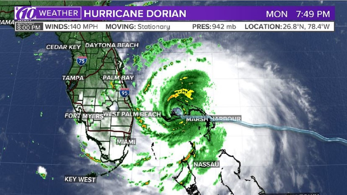
7:23 p.m. update:
SeaWorld Orlando announced it will be closed Tuesday in advance of Hurricane Dorian. This is in addition to the several early closures at Walt Disney World.
5:20 p.m. update:
Bahamas Prime Minister Hubert Minnis says at least five people have died in the Abaco Islands.
-- The Associated Press
5:13 p.m. update:
Walt Disney World announced it will adjust its schedule Tuesday as Hurricane Dorian makes an approach.
Magic Kingdom Park will open at 8 a.m. for all guests but close early at 3 p.m., according to its website. Epcot will open at 7 a.m. and close at 3 p.m.
The Animal Kingdom opens at 8 a.m. and closes at 2 p.m., while Disney's Hollywood Studios will open at 9 a.m. and close at 2 p.m.
5 p.m. update:
Hurricane Dorian basically is at a standstill as it continues slamming the Bahamas. The National Hurricane Center said the storm is stationary.
It remains a powerful, 145-mph Category 4 storm.

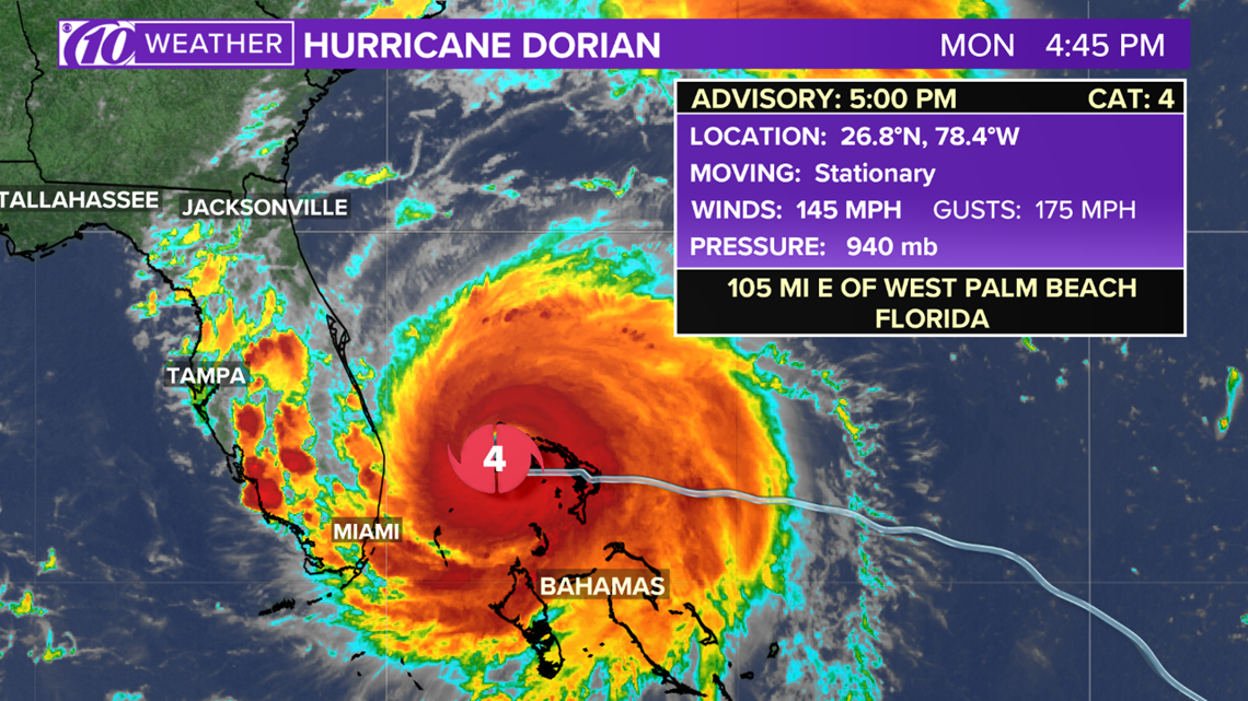
4:25 p.m. update:
Orlando International Airport announced it will cease commercial operations at 2 a.m. Tuesday ahead of Hurricane Dorian.
4:05 p.m. update:
The NOAA Hurricane Hunters published video of its mission Sunday into the eye of then-Category 5 Hurricane Dorian.
You can clearly see what's known as the "stadium effect" in the storm's eye. This phenomenon appears in the strongest of tropical cyclones, with the eye appearing to slope down from the top of the storm to the bottom.
3:28 p.m. update:
A tweet from the Bahamas Press shows people in Freeport taking shelter in their attics. However, Hurricane Dorian's strong winds are creating storm surge and waves large enough to reach the roof.
Government officials earlier told people to break their roofs with hammers to escape rising the rising water.
3:20 p.m. update:
Clay County, Florida, is the latest to order a mandatory evacuation. It begins at 3 p.m. Tuesday and is in effect for people in Zones A, B, low-lying areas and mobile homes.
10News is following the latest evacuation orders, here:
2:39 p.m. update:
The University of Central Florida announced it will remain closed through Thursday, Sept. 5, in advance of Hurricane Dorian.
2 p.m. update:
Hurricane Dorian is inching to the west-northwest at 1 mph, as it continues to devastate the Bahamas.
As of the 2 p.m. National Hurricane Center update, the Category 4 hurricane was about 25 miles northeast of Freeport and roughly 105 miles east of West Palm Beach, Florida.
The storm is producing winds up to 150 mph.
1:42 p.m. update:
The first sustained tropical-storm-force wind from Hurricane Dorian has been reported in South Florida. Sustained winds of 40 mph were reported at Juno Beach Pier just before 1 p.m. There were gusts as high as 48 mph, according to the National Weather Service.
1:20 p.m. update:
Authorities are telling people to break roofs with hammers to escape rising floodwaters in the Bahamas. An emergency management agency on the islands hasn't tweeted in 10 hours.
"We need you to bunker down," Kwasi Thompson, minister of state for Grand Bahama, warned people. "It's going to be another 10-12 hours that we're going to be bombarded with this."
Thompson and other officials said they received distress calls about rising floodwaters, but rescuers could not go out in the violent conditions.
RELATED: People told to break roofs with hammers to escape flooding as Hurricane Dorian assaults Bahamas
12:15 p.m. update:
Video from CBS affiliate WKMG in Orlando shows a time-lapse of some of the first rain bands from Hurricane Dorian reaching Florida's east coast.
11:16 a.m. update:
We're beginning to get early glimpses of the devastation caused by Hurricane Dorian in the Bahamas. The below video shows a parking lot full of damaged cars at Abaco Beach Resort.
11:00 a.m. update:
Hurricane Dorian has been downgraded to a Category 4 storm. Maximum sustained winds have decreased to 155 mph. The storm is about 30 miles northeast of Freeport in the Bahamas. It's still crawling west at just 1 mph.
The storm surge warning and hurricane warnings have been extended northward along the east coast of Florida to the Flagler/Volusia County line. A hurricane watch has been extended north to Altamaha Sound in Georgia. The storm surge watch has been extended north along the Georgia coast to the Savannah River.

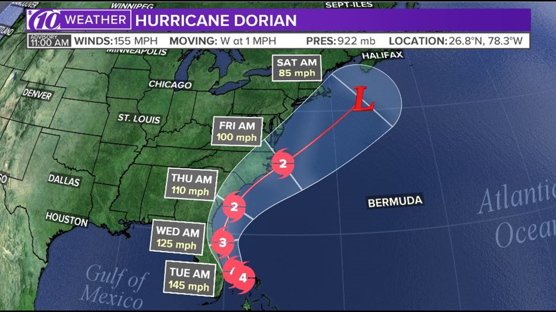
10:45 a.m. update:
At a news conference Monday morning, Florida Gov. Ron DeSantis told Floridians if they were in an evacuation zone to get out, and get fuel for your vehicle.
"We're going to have some impacts one way or another," DeSantis said.
DeSantis said he spoke with the president who said he was, "fully engaged," and will provide whatever is needed.
Seventy-two nursing and assisted living homes have been evacuated along the East Coast.
10 a.m. update:
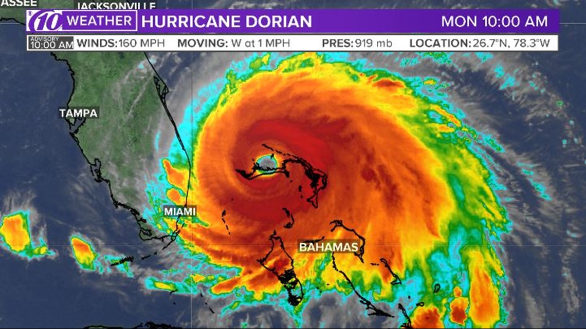
Weather forecasters say Hurricane Dorian's wind strength has dropped slightly Monday, though it continues to pummel the Bahamas with destructive wind and rain.
The National Hurricane Center in Miami said at 10 a.m. EDT that the maximum sustained wind speed was most recently clocked at 160 mph (260 kph), down from 165 mph.
Still, Dorian remained an extremely dangerous, life-threateneing Category 5 storm, the center said.
The storm was crawling slowly west at 1 mph, with its center 30 miles east-northeast of Freeport, Grand Bahama Island and 115 miles east of West Palm Beach.

9 a.m. update:
A spokesman for Bahamas Power and Light says there has been a total blackout in New Providence, the archipelago's most populous island.
Quincy Parker told ZNS Bahamas radio station on Monday morning that crews are working to restore power on the island that lies south of the path that Hurricane Dorian is expected to take.
Parker said officials are anxious for the storm to pass so they can start rebuilding.
8 a.m. update:
Hurricane Dorian is still moving slowly over Grand Bahama, according to the NHC's latest advisory. The Category 5 storm is moving west at 1 mph with a minimum central pressure of 916 mb.
Maximum sustained winds remain at 165 mph.
7 a.m. update:
The U.S. National Hurricane Center in Miami says the eye of Hurricane Dorian is "wobbling" over the Bahamas' northernmost island.
Still, residents of Grand Bahama are advised to remain in their shelters, as dangerous winds will pick back up once the eye passes.
Top sustained winds remain at 165 mph and the Category 5 storm continues to inch west at just 1 mph.
Dorian is expected to continue lashing the Bahamas on Monday, before moving closer to the southeastern U.S. coast Monday night through Wednesday evening.
6:20 a.m. update:
Storm surge warning in effect for:
- Lantana to the Volusia/Brevard County Line
Storm surge watches in effect for:
- North of Deerfield Beach to Lantana
- Volusia/Brevard County Line to the mouth of the St. Mary's River
Hurricane warnings in effect for:
- Grand Bahama and Abacos Islands in the northwest Bahamas
- Jupiter Inlet to the Volusia/Brevard County Line
Hurricane watches in effect for:
- North of Deerfield Beach to Jupiter Inlet
- Volusia/Brevard County Line to the mouth of the St. Mary's River
Tropical storm warnings in effect for:
- North of Deerfield Beach to Jupiter Inlet
Tropical storm watches in effect for:
- North of Golden Beach to Deerfield Beach
- Lake Okeechobee
5:05 a.m. update:
Hurricane Dorian continues to lash the northern Bahamas as it crawls westward toward the southeastern U.S. coast.
The National Hurricane Center in Miami says the Category 5 storm's top sustained winds remain at 165 mph Monday morning, down from Sunday's high of 185 mph. The center of the storm is around 40 miles east of Grand Bahama's largest city, Freeport, and 115 miles east of West Palm Beach.
The newest advisory indicates that the east-central coast of Florida may experience a "brief tornado" Monday afternoon or evening.
The government of the Bahamas has discontinued the hurricane warning for New Providence and Eleuthera, and the hurricane watch for Andros island.
4:40 a.m. update:
Commercial flights in/out of Palm Beach International Airport have been canceled for today. Fort Lauderdale International is closing at 12 p.m. Daytona International says flights are a go, however, travelers should contact their airlines for flight information. Orlando International is open. Jacksonville International remains open but travelers are encouraged to call ahead.
All airports on the west coast of Florida are open.
3 a.m. update:
Hurricane Dorian's eye is crawling over the Bahamas' northernmost island, but residents are warned not to leave their shelters.
The National Hurricane Center in Miami says Dorian's top sustained winds have further decreased to 165 mph. The Category 5's movement has slowed to a 1 mph crawl westward.
The 4 a.m. advisory warns residents on Grand Bahama to remain in their shelters as the eye passes over, as winds will rapidly pick back up once the eye moves.
Residents of the islands where the hurricane first hit are also advised to remain in their shelters until conditions improve later Monday.
The center of the storm is around 40 miles east of Grand Bahama's largest city, Freeport. It's also around 125 miles east of West Palm Beach.
SUNDAY, SEPT. 1
►Stay informed with all tropical weather: Check out our must-have interactive Hurricane Headquarters guide here.
11 p.m. update:
Catastrophic Category 5 Hurricane Dorian made landfall on the eastern end of Grand Bahama Island. It is continuing to move to the west at 6 mph. Wind speeds have dropped to 180 mph.
A Hurricane Watch has been extended northward from the Flagler/Volusia County Line to the Mouth of the St. Mary's River.
A Storm Surge Watch has also been extended northward from the Flagler/Volusia County Line to the Mouth of the St. Mary's River.
10 p.m. update:
The Fort Lauderdale-Hollywood International Airport plans on closing Monday at noon as it braces for the possible impact of Hurricane Dorian.
8 p.m. update:
Category 5 Hurricane Dorian is pounding Great Abaco and Grand Bahama Island.
The storm is moving west at 5 mph and is about 155 miles east of West Palm Beach, Florida.
There were no new watches or warnings issued with this advisory from the National Hurricane Center.
7:10 p.m. update:
Hardee County schools cancel all classes for Tuesday.
5. p.m. update:
The eye of catastrophic Hurricane Dorian is crawling over the Abacos Islands in the Bahamas. It is moving west at 5 mph. Sustained winds remain at 185 mph with gusts at 225 mph.
The storm's track is now taking aim towards Grand Bahama.
A Storm Surge Warning has been issued from Lantana to the Volusia/Brevard County Line. A Storm Surge Watch has been issued from the Volusia/Brevard County Line to the Flagler/Volusia County Line. A Hurricane Warning has been issued from Jupiter Inlet to the Volusia/Brevard County Line.
The storm is about 175 miles east of West Palm Florida.
4 p.m. update:
Hurricane Dorian'swinds are now up to 185 mph. Hazards for the Abacos are wind gusts over 220 mph and storm surge of 18-23 feet. The eye is right on top of Abaco Island.
3 p.m. update:
The National Hurricane Center advises those in the Abacos Islands to stay inside as the "life-threatening" Hurricane Dorian passes over the Bahamas.
Dorian made its first landfall around 12:45 p.m. at Elbow Cay. Wind gusts have been as high as 220 mph. Storm surge is expected to be 18-23 above normal tide levels with possible higher destructive waves.
Maximum sustained winds remain at 185 mph and the storm is moving west at 7 mph. The minimum central pressure is 910 mb.
2 p.m. update:
Category 5 Hurricane Dorian is currently over Great Abaco Island in the Bahamas and moving west at about 7 miles per hour.
The minimum central pressure, an indication of the storm's strength, is 911 mb. Typically, lower pressures correlate with higher wind speed.
According to the latest NHC advisory, Dorian is "heading with all its fury toward Grand Bahama."
1:38 p.m. update:
Florida Gov. Ron DeSantis said tolls are being suspended at the 25-mile marker and the 100-mile marker on I-75 (Alligator Alley). Tolls are also being waived along portions of the Florida Turnpike.
The roads where tolls are being waived include Sawgrass Express, 520 Beachline and East-West Beltway in Orlando. There are no bridge closures as of Sunday afternoon.
12:56 p.m. update:
Hurricane Dorian made landfall in Elbow Cay, Abacos, a cay in the Bahamas. Maximum sustained winds have increased again to 185 mph. Minimum central pressure also fell to 911 mb.
11:10 a.m. update:
A tropical storm watch has been issued for Polk County and Highlands County in Central Florida, according to the National Weather Service.
11 a.m. update:
Hurricane Dorian now has maximum sustained winds of 180 miles per hour, according to the National Hurricane Center's latest advisory.
Dorian is about 20 miles east-northeast of Great Abaco Island in the Bahamas with a minimum central pressure of 913 mb.
A hurricane watch has been issued for the east coast of Florida from north of Deerfield Beach to the Volusia/Brevard County line.
A storm surge watch has been issued from north of Deerfield Beach to the Volusia/Brevard County line.
The NHC said Dorian is now the strongest hurricane in modern records for the northwestern Bahamas.
10:30 a.m. update:
Mandatory evacuation orders have been issued for coastal areas (Zones A and B) of Palm Beach County and Martin County, Florida.
The Palm Beach County Sheriff's Office said Zone A includes mobile homes, sub-standard housing and low-lying areas prone to flooding. Zone B includes the barrier islands, land areas north and south of the Jupiter Inlet and other areas vulnerable to storm surge along the Intracoastal Waterway to Broward.
9:30 a.m. update:
NOAA's Hurricane Hunters found Dorian's winds have increased to 175 miles per hour as the storm approaches the Bahamas. The eyewall is currently reaching the Abaco Islands in the northwestern Bahamas.
Hazards for the island include wind gusts over 200 miles per hour and storm surge 15-20 feet above normal tide levels with possible higher waves.
Residents are asked to take immediate shelter and not venture into the eye if it passes over.
8 a.m. update:
Hurricane Dorian has intensified into a "catastrophic" 160-mph Category 5 storm, according to the National Hurricane Center's latest advisory.
Forecaster say the eyewall -- the most powerful part of the hurricane -- is about to hit the Abaco Islands in the Bahamas, bringing with it life-threatening storm surge.
7:15 a.m. update:
Hurricane Dorian is still churning over the Atlantic, heading gradually toward the Bahamas where the impact could be disastrous.
As the storm ramps up – it has been classified as Category 4 since Friday, Aug. 30 – weather experts are drawing comparisons to a 2016 hurricane with a path similar to the one Dorian might follow.
Hurricane Matthew made headlines in late September 2016 when it formed off of the west coast of Africa and then moved westward for an eventual landfall along the coasts of southwestern Haiti, eastern Cuba and western Grand Bahama Island.
5 a.m. update:
Tropical storm warnings have been posted from Deerfield Beach to Sebastian Inlet, Florida, in advance of Hurricane Dorian's winds. A tropical storm watch is in effect from north of Golden Beach to Deerfield Beach.
A warning means tropical-storm-force winds in excess of 39 mph are expected within the next 36 hours.
As of the National Hurricane Center's latest advisory, Hurricane Dorian remains a 150-mph, Category 4 storm as it churns toward the Bahamas.
3:52 a.m. update:
The Air Force Reserve Hurricane Hunters arrived home to Keesler Air Force Base, Mississippi, overnight and brought back a few stunning pictures from inside the eye of Hurricane Dorian.
2:18 a.m. update:
A dangerous Hurricane Dorian closed in on the northern Bahamas early Sunday, threatening to batter islands with 150 mph winds, pounding waves and torrential rain as people hunkered down in schools, churches and other shelters.
Millions from Florida to the Carolinas kept a wary eye on Dorian, meanwhile, amid indications it would veer sharply northeastward after passing the Bahamas and track up the U.S. Southeast seaboard. But authorities warned even if its core did not make U.S. landfall and stayed offshore, the potent Category 4 storm would likely hammer U.S. coastal areas with powerful winds and heavy surf.
In the northern stretches of the Bahamas archipelago, hotels closed, residents boarded up homes and officials hired boats to move people from low-lying areas to bigger islands as Dorian approached.
Bahamas Prime Minister Hubert Minnis warned that Dorian is a "dangerous storm" and said any "who do not evacuate are placing themselves in extreme danger and can expect a catastrophic consequence."
--The Associated Press
2 a.m. update:
Dorian remains an extremely dangerous, 150-mph Category 4 storm as of the National Hurricane Center's latest advisory. It is about 95 miles east of Great Abaco Island in the Bahamas, moving west at 8 mph.
Prolonged life-threatening storm surge and devastating hurricane-force winds are expected Sunday through early Monday for the northwest Bahamas.
SATURDAY, AUG. 31
►Stay informed with all tropical weather: Check out our must-have interactive Hurricane Headquarters guide here.
11 p.m. update:
There are no major changes to the intensity or track of Hurricane Dorian. The storm remains a powerful Category 4 heading west towards the Bahamas at 8 mph.
The main changes observed today were a slight shift in the track back towards the Florida coast and a drop in pressure to 940 mb. 150 mph winds have remained consistent throughout the day, despite the slight pressure drop.
The latest track has Dorian staying close to the Bahamas for a couple of days as a Category 4 before continuing its path up the United States coast.
Tropical Storm Watches are still in effect for parts of the Florida east coast, specifically from Deerfield Beach up to Sebastian's Inlet.
8 p.m. update:
The NOAA Hurricane Hunter aircraft flew through Hurricane Dorian and reaffirmed its Category 4 strength. Sustained winds are still 150 mph.
7:35 p.m. update:
10News Meteorologist Autumn Robertson here. We're continuing to watch Dorian tonight as it travels west through the Caribbean at 8 mph. The storm made little changes all day and continues to churn in the Atlantic as a strong Category 4 storm with winds near 150 mph.
There remains some uncertainty on when and where a north turn will occur, and that will ultimately decide how much this storm will impact Florida. Models are still agreeing on a more easterly track once the storm nears the Florida coast.
Very warm waters and low wind shear will help the storm maintain or grown in intensity in the Atlantic within the next couple of days.
5:28 p.m. update:
Polk County announces its shelters will no longer open because Hurricane Dorian's direct path has shifted to the east.
4:55 p.m. update:
Hurricane Dorian is expected to hit parts of the northwestern Bahamas on Sunday, and those areas should be ready for some dangerous conditions.
A tropical storm watch has been issued for the east coast of Florida from Deerfield Beach to Sebastian Inlet.
4:30 p.m. update:
The Pasco County Sheriff's Office had its Jeep crew head out and give people who are elderly and people with disabilities sandbags.
3:32 p.m. update:
Sarasota County Emergency Services is deescalating the county's Hurricane Dorian response.
3:30 p.m. update:
Hurricane Dorian hasn't changed much in the past few hours, as it is currently heading for the Bahamas as a strong Category 4 storm with winds up to 150 mph and a central pressure of 945 mb. The storm is projected to hit the northwest Bahamas on Sunday before curving upward towards the Florida coast.
The next advisory will be issued at 5 p.m.
2:40 p.m. update:
Brevard County emergency officials are delaying the mandatory evacuations by 24 hours and are now calling for evacuations to begin at 8 a.m. Monday because Hurricane Dorian has slowed down, although it has remained strong. Click or tap here for the latest information.
1:55 p.m. update:
Hurricane Dorian is currently heading for the northwestern Bahamas as a strong Category 4 storm with winds up to 150 mph. Prolonged life-threatening storm surge and devastating hurricane-force winds are expected Sunday through early Monday for the northwest Bahamas. Right now, Dorian is located about 205 miles east of Great Abaco in the Bahamas.
1:20 p.m. update:
A quick update from the 10News Weather Center - Meteorologist Grant Gilmore here. Forecast models from this morning have been coming in and we are continuing to see the shift to the east in the track of Hurricane Dorian after it turns to the north. There remains some uncertainty on when/where that turn to the north will occur, but the general consensus in the models is for that turn to happen before reaching the Florida coast. We will get our next advisory from the National Hurricane Center at 2:00 pm.
12:40 p.m. update:
The Tampa Bay Rays are offering free tickets to Floridians forced to evacuate the state's east coast due to Hurricane Dorian. You will have to show your driver's license, and it's only while tickets last. Click here for more information.
12 p.m. update:
Hey everyone, this is 10News Meteorologist Grant Gilmore. Hurricane Hunters have been flying through the storm all morning and have found that the storm is strengthening. The storm is a very strong category 4 hurricane as of this update with wind speeds up to 150 mph.
Wind speeds of 157 mph or stronger is the threshold for a category 5 storm. Some strengthening is expected as the storm moves over some warmer water, which is like high octane-fuel for hurricanes.
One thing that could cause the storm to weaken slightly would be the process of another eyewall forming around the current eye. This process called and 'eyewall replacement cycle" typiceally gives way to some weakening before an opportunity to strengthen once again. This will likely cause the storm to have fluctuations in intensity in the coming days, but it is still forecast to remain a very strong hurricane as it approaches the northeast Bahamas on Sunday.
A turn to the north is forecast to occur Sunday night, but the time/location of the turn is still not completely certain. The general consensus in the forecast models has been to have that turn occur sooner which would keep the center of the storm off the east coast of Florida. Due to this shift in forecast models the National Hurricane Center also continues to slightly shift their official forecast to the right. That said, the National Hurricane Center continues to warn that the threat of life-threatening storm surge and dangerous hurricane-force winds are still possible along portions of the Florida east coast by the early to middle part of next week. Due to the uncertainty of when Dorian will actually turn northward near or just offshore of the east coast, they note that it still too soon to determine when or where the highest surge and winds could occur. Anyone along the east coast of Florida should keep their hurricane plan in place, know if they are in a hurricane evacuation zone, and listen to advice given by local emergency officials.
11 a.m. update:
Hurricane Dorian remains a Category 4 hurricane with winds up to 150 mph.
9:45 a.m. update:
Gov. Ron DeSantis is warning Floridians not to let their guard down despite shifts in forecasts showing Hurricane Dorian possibly staying off the shore of the state. The cone of potential pathways still includes much of the state, and DeSantis says if residents are within that cone they should be prepared.
"Looking at these forecasts, a bump in one direction or the other could have really significant ramifications in terms of impact. If it bumps further east, that obviously is positive. If it bumps just a little west, than you're looking at really, really significant impacts. Don't make any assumptions, remain vigilant and be prepared," DeSantis said at a briefing Saturday morning.
9:15 a.m. update:
Pinellas County declares a local state of emergency in advance of possible impacts from Hurricane Dorian.
9 a.m. update:
"Remain vigilant and be prepared:" Florida Gov. Ron DeSantis during a briefing on how the state is preparing for Hurricane Dorian said the forecast is looking increasingly positive.
However, he asked people not to over-read the forecast track because it is likely to change.
The governor also said he and other state officials are monitoring traffic flows and will announce any changes to tolls if and when necessary.
"We do not see any abnormal traffic on the roadways," DeSantis said.
7:44 a.m. update:
The NOAA Hurricane Hunters have found Hurricane Dorian a little stronger, now at 145 mph. It remains a Category 4 storm and while some fluctuations in intensity are possible, the hurricane center says, Dorian is poised to remain a powerful hurricane.
7:33 a.m. update:
For the best view of Hurricane Dorian, fly right into the eye. It's exactly what the NOAA Hurricane Hunters have done this morning. Courtesy of Paul Chang, the crew got a look inside the eye of the Category 4 storm.
6:21 a.m. update:
Seeing the eastward shift in the track, the potential risks for the Tampa Bay region also have been adjusted.
It's possible tropical-storm-force winds could be felt, especially in Highlands and Polk counties. And because of the nature of a slow-moving storm, any impacts could last four a couple of days.
5 a.m. update:
There are no major changes in Hurricane Dorian's intensity with the National Hurricane Center's latest advisory. It remains a Category 4 storm with maximum sustained winds of 140 mph.
However, and this is good news for Tampa Bay, eastward trends in the weather models have been reflected in the hurricane center's cone of uncertainty. Some areas of southwest Florida have been removed from the cone, and there's hope the storm will eventually make a move northward and stay away from a Florida landfall.
Everyone in the cone needs to keep an eye on later forecasts.
3:45 a.m. update:
The latest weather computer models are in, and the American and European weather computer models are of some sort of agreement into Hurricane Dorian's potential path.
It is important to note computer models are not forecasts and are subject to change. However, they are encouraging signs Dorian might stay far enough east from Florida's east coast. They also show potential impacts to Georgia and the Carolinas, so people all along the Southeast U.S. need to monitor later forecasts.
2 a.m. update:
Hurricane Dorian continues moving toward the Bahamas as a powerful, 140-mph Category 4 storm as of the National Hurricane Center's latest update. It's possible Dorian could continue strengthening.
Forecasters expect the storm to slow down later Saturday and track closer to the Bahamas.
FRIDAY, AUG. 30
►Stay informed with all tropical weather: Check out our must-have interactive Hurricane Headquarters guide here.
11 p.m. update:
Hurricane Dorian remains a Category 4 storm with winds still at 140 mph. It is forecast to strengthen to 150 mph, then lower as it approaches Florida.
9:20 p.m. update:
Mandatory evacuation orders were issued for parts of Brevard County ahead of Hurricane Dorian. Brevard County Emergency Management leaders announced the order Friday night.
8:30 p.m. update:
Hi, this is 10News Meteorologist Autumn Robertson. Hurricane Dorian has just strengthened to become a Category 4 storm with winds at 130 mph as it heads northwest toward Florida. It's expected to reach the state by Monday afternoon.
8 p.m. update:
The Hurricane Hunter aircraft found that Hurricane Dorian has strengthened. The Category 3 storm now has winds of 125 mph. Hurricane Dorian is expected to continue gaining strength.
5 p.m. update:
Hurricane Dorian could now make landfall as a Category 4 hurricane, based on the latest data from the National Hurricane Center. The most recent track shows it making landfall Tuesday along Florida's east coast with 140 mph winds.
4:30 p.m. update:
Orlando International Airport announced it is stopping commercial flight operations at 2 a.m. Monday. Passengers are being asked to check with their individual airlines for updated flight information.
4:01 p.m. update:
Pasco County schools said they would be closed through Tuesday.
3:58 p.m. update:
Hillsborough County schools will be closed through Tuesday before a possible Hurricane Dorian landfall in Florida.
3:48 p.m. update:
Hernando County schools announced they will be closed through Tuesday, Sept. 3, ahead of Hurricane Dorian.
3:35 p.m. update:
Pinellas County schools canceled classes through Tuesday ahead of Hurricane Dorian. School-related activities were also canceled ahead of the storm.
3:25 p.m. update:
All Citrus County schools will be closed through Tuesday in preparation for Hurricane Dorian.
3 p.m. update:
Gov. DeSantis has launched the Florida Disaster Fund, the State of Florida’s official private fund established to assist Florida’s communities as they respond to and recover during times of emergency or disaster. To donate, please visit www.volunteerflorida.org or text DISASTER to 20222 to make a $10 contribution.
2 p.m. update:
Hurricane Dorian has officially turned into a major hurricane as a category 3 storm. The storm currently has maximum sustained wind speeds at 115-mph and is moving northwest at 10 mph.
1:22 p.m. update:
Highland County Public Schools will be closed Labor Day Monday, Tuesday and Wednesday in response to Hurricane Dorian.
Public schools and district offices in Polk County will be closed on Labor Day Monday, Sept. 2, Tuesday, Sept. 3, and Wednesday, Sept. 4, in response to Hurricane Dorian.
12:40 p.m. update:
Fixed route transit services are being suspended in Polk County ahead of Hurricane Dorian's anticipated landfall in Florida. Citrus Connection, which provides bus service, will stop driving its fixed routes at the close of business on Friday. And, there's no word yet on when service will begin again. Operators will still help with addressing the medical needs of Citrus Connection clients. For more information, call the Regional Mobility Call Center at 863-534-5500.
12:25 p.m. update:
Florida Gov. Ron DeSantis is holding a hurricane briefing in Palm Beach County. He is announcing that evacuation orders will be issued in parts of Palm Beach County sometime Friday. Once the orders are issued, the state will suspend tolls to help people evacuate.
12:00 p.m. update:
President Donald Trump has approved Florida's pre-landfall emergency declaration and ordered federal help to support state and local efforts to deal with Hurricane Dorian, which is expected to make landfall as a major storm on the state's east coast. The White House has authorized the Federal Emergency Management Agency (FEMA) to coordinate disaster relief efforts and to help all 67 Florida counties.
11:30 a.m. update:
Polk County has declared a local state of emergency ahead of Hurricane Dorian, joining Manatee and Hernando counties in their emergency declarations Friday Morning.
Highlands, Hillsborough, Hardee and Pasco counties had already declared states of emergency, along with the City of Venice. A state-level emergency declaration was previously put in place by Florida Gov. Ron DeSantis.
11 a.m. update:
Hurricane Dorian has maintained its strength as a category 2 storm with 110 mph winds. Dorian is currently posing a "significant threat" to Florida and the northwestern Bahamas, according to the National Hurricane Center.
A Hurricane Watch is in effect for the northwestern Bahamas.
9:30 a.m. update:
Good morning everyone, 10 News Meteorologist Grant Gilmore here with just a quick mention about the forecast for today and the next couple of days. While most of the area is enjoying a fair amount of sunshine this morning there will be fairly widespread showers and storms this afternoon. Right now I am forecast a 70% chance of rain for the entire Tampa Bay area. I want to make sure you know that this IS NOT associated with Hurricane Dorian. Over the next few days, we will have a continued 70% chance of scattered afternoon showers and storms (some will produce pretty heavy rain), but all of them will not be related to the approaching hurricane. At this time it doesn't look like we would begin to feel the impacts of Dorian until Monday evening. The extent/details of those impacts are heavily dependent on the exact track of Dorian, which is just too far out to nail down at this time. In the meantime, watch out for those afternoon showers and storms.
8 a.m. update:
An Air Force Reserve plane has determined Hurricane Dorian has grown a little stronger, with maximum sustained winds increasing to nearly 110 mph -- with higher gusts. Dorian is expected to keep growing stronger and become a major hurricane later today.
The National Hurricane Center expects Dorian to remain an "extremely dangerous hurricane" while it moves near the northwestern Bahamas and approaches the Florida peninsula during the weekend.
At this point, the center of the storm is about 225 miles east-northeast of the southeastern Bahamas. Hurricane-force winds are extending out up to 25 miles from the center, and tropical-storm-force winds can be found up to 105 miles outward.
At this point, it's still a Category 2 hurricane, but it's expected to be a Category 3 storm by later today and a Category 4 storm by Friday.
The 5 a.m. version of the anticipated track is still the most current. You can find that below.
5 a.m. update:
Hurricane Dorian remains a Category 2 storm with winds up to 105 mph.
3:15 a.m. update:
Unsure where Hurricane Dorian is going to land over Labor Day weekend, many Florida residents faced a sense of helplessness as the storm approaches.
The National Hurricane Center said the Category 2 storm is expected to strengthen into a potentially catastrophic Category 4 and slam into the U.S. on Monday somewhere between the Florida Keys and southern Georgia.
With the storm's track still unclear, no immediate mass evacuations have been ordered.
THURSDAY, AUG. 29
11:00 p.m. update
Hurricane Dorian strengthened into a Category 2 storm Thursday night, according to the 11 p.m. update from the National Hurricane Center.Hurricane Dorian has sustained winds of 105 miles-per-hour. It is moving northwest at about 12 miles-per-hour. Hurricane Dorian is located at about 295 miles east, northeast of the Southeastern Bahamas.
5:00 p.m. update
Hurricane Dorian continues to move northwest at about 13 miles-per-hour. It has sustained winds of 85 miles-per-hour. The National Hurricane Center says it expects Hurricane Dorian to keep moving this way though Friday before it starts to make a westward motion.
4:00 p.m. update:
The Florida Department of Transportation suspended all interstate lane closures in the Tampa Bay area ahead of Hurricane Dorian's possible arrival.
All available lanes will remain open on the interstate system in Hillsborough, Pinellas, Pasco and Hernando counties.
11:05 a.m. update:
Meteorologists Grant Gilmore and Natalie Ferrari are answering your questions about the latest forecast track now over on Facebook.
11 a.m. update:
Hurricane Dorian is now forecast to be a Category 4 storm at landfall. The storm is still a category 1 storm as it moves northwestward.
The National Hurricane Center says rapid strengthening remains a possibility, although not likely in the very short term given the concentric eyewall structure. There are also still some questions concerning the exact track of the storm, and it is too soon to determine where the strongest winds will occur.
Regardless of the exact track of Dorian, heavy rains are expected to occur over portions of the Bahamas, Florida, and elsewhere in the southeastern United States this weekend and into the middle of next week.
8 a.m. update:
Tropical-storm-force winds from Dorian could begin in parts of Florida as early as Saturday evening, the National Hurricane Center says.
5 a.m. update:
Dorian is a Category 1 hurricane with maximum sustained winds of 85 mph. The storm is moving NW at 13 mph. The National Hurricane Center says the storm is expected to become a major hurricane over the next few days.
2 a.m. update:
Hurricane Dorian is moving over open waters after doing limited damage in Puerto Rico and the Virgin Islands, though forecasters warn it is gaining strength and probably will grow into a dangerous storm while heading toward Florida's east coast.
The U.S. National Hurricane Center said late Wednesday Dorian is expected to strengthen into a dangerous Category 3 hurricane as it stays well to the east of the southeastern and central Bahamas over the next two days. The forecast calls for the storm to pass near or over the northern Bahamas on Saturday and close in on Florida by Sunday afternoon.
The storm was a Category 1 hurricane Wednesday when it swirled through the islands of the northeastern Caribbean, causing power outages and flooding in places no major damage.
WEDNESDAY, AUG. 28
11 p.m. update:
The NOAA Hurricane Hunters find Dorian's maximum sustained winds have gone up to 85-mph, according to the National Hurricane Center's latest advisory.
In addition to the wind increase, the team found the storm's minimum central pressure has gone down to 986 mb. Continued falling pressure means the storm is continuing to intensify.
10:20 p.m. update:
Florida Gov. Ron DeSantis and U.S. Sen. Rick Scott spoke with President Donald Trump ahead of Hurricane Dorian's potential impacts to the state.
Trump reportedly told them the federal government is ready to help if and when necessary. DeSantis on Twitter said Trump reassured him with the support.
"Spoke with @realDonaldTrump @POTUS tonight at 8:45 pm to give him an update on #HurricaneDorian and he reassured me that #Florida has the full support of the federal government as residents prepare for the storm."
8 p.m. update:
The latest advisory from the National Hurricane Center keeps the same, 80-mph maximum sustained wind speed as the last update, however, Hurricane Dorian's pressure has fallen.
This is an indication the storm has entered a period of intensification.
Dorian remains forecast to eventually make a turn from the Caribbean islands and toward the southeast U.S. coastline. The storm could make landfall anywhere from the Keys to potentially Georgia as indicated by the cone of uncertainty.
6:40 p.m. update:
MacDill Air Force Base in Tampa is under HURCON 5 as ordered by its commander. This means destructive winds are possible within 96 hours.
It tweeted staff there is working to prepare the base for possible impacts from Hurricane Dorian, and people should do the same for their homes and families.
5:45 p.m. update:
Florida Attorney General Ashley Moody activated the state's Price Gouging Hotline as Gov. Ron DeSantis declares a state of emergency for counties in Hurricane Dorian's path.
The state's price gouging law only applies within the affected state of emergency area, a news release states.
Price gouging can be reported by calling 866-9NO-SCAM or on the NO SCAM app.
5 p.m. update:
The latest cone of uncertainty track for Hurricane Dorian even more so centers on a possible landfall somewhere along Florida's east coast. However, do not pay attention to the exact center of the cone -- forecasters suspect the storm to make landfall anywhere from the Keys to south Georgia.
Dorian is an 80-mph storm moving away from the northeastern Caribbean Sea. The National Hurricane Center says Dorian is expected to become a dangerous hurricane this weekend as it nears the Florida coast.
4:48 p.m. update:
Florida Gov. Ron DeSantis has declared a state of emergency in advance of a potential landfall by Hurricane Dorian. He urges all residents, especially those along the east coast, to be mindful of the storm's forecast.
“Today, I am declaring a state of emergency to ensure Florida is fully prepared for Hurricane Dorian,” DeSantis said in a news release. “It’s important for Floridians on the East Coast to monitor this storm closely. Every Florida resident should have seven days of supplies, including food, water and medicine, and should have a plan in case of disaster.
"I will continue to monitor Hurricane Dorian closely with emergency management officials. The state stands ready to support all counties along the coast as they prepare.”
4 p.m. update:
The Coast Guard asks the maritime community across the Tampa Bay region to take necessary precautions in advance of possible impacts from Hurricane Dorian.
In short, boaters should make sure their belongings are secured. Trailer-able boats should be taken out of the water and stored in a place not prone to flooding, the Coast Guard said.
Boaters can monitor the storm on VHF radio channel 16.
2:48 p.m. update:
Friday's game between the University of South Florida and Wisconsin is not expected to be affected by Hurricane Dorian, according to USF Athletics.
However, it will remain monitored.
"We are following closely the track and timing of the storm. Based on current models, which have the storm well off the east coast of Florida on Saturday, we do not anticipate an impact on Friday's USF vs Wisconsin game. We ill continue to monitor and provide updates of any changes."
2:30 p.m. update:
OneBlood is asking people to donate blood as preparation for Hurricane Dorian. All blood types are needed, but there is an increased need for O Negative and O Positive blood as well as platelet donations, according to OneBlood.
1:45 p.m. update:
Tropical Storm Dorian strengthens to a Category 1 hurricane near St. Thomas in the U.S. Virgin Islands. Hurricane Dorian has sustained winds of 75 mph.
It is moving northwest at 13 mph.
1:30 p.m. update:
There is now a Hurricane Warning issued for the US and the British Virgin Islands, Vieques and Culebra. There is also a Tropical Storm Warning and Hurricane Watch for Puerto Rico and a Tropical Storm Watch for the Dominican Republic from Isla Soana to Samana.
Tropical-storm-force winds from Dorian could begin in parts of Florida as early as Saturday.
11 a.m. update:
Based on the latest forecast track, Tropical Storm Dorian is now expected to strengthen to a Category 3 hurricane as it approaches the continental United States.
Tropical Storm Dorian is headed towards the U.S and British Virgin Islands and Puerto Rico and is producing sustained winds at around 70 mph.
The center of the storm is located close to St. Croix.
Dorian is expected to reach hurricane strength by Wednesday afternoon and strengthen to a Category 3 storm by Sunday morning.
8 a.m. update:
Tropical Storm Dorian is moving closer to the Virgin Islands and Puerto Rico. As of this time, Dorian is about 60 miles southeast of St. Croix and producing maximum sustained winds of nearly 60 mph.
5 a.m. update:
Based on the latest forecast track, Dorian is now expected to be around Category 2 hurricane strength by the time it approaches Florida or the southeast U.S. coast -- likely around Sunday or Monday.
In the meantime, a hurricane watch is in effect for Puerto Rico, Vieques, Culebra and the U.S. Virgin Islands.
2 a.m. update:
Dorian has strengthened slightly, and tropical storm conditions are expected in Puerto Rico and the Virgin Islands later today. At this point, the storm is located about 240 miles east-southeast of Ponce, Puerto Rico.
Maximum sustained winds are being reported at 60 mph.
The storm is moving northwest at nearly 13 mph, and this general motion will likely continue through tomorrow. We're expecting Dorian to pass over or near Puerto Rico and the U.S. and the British Virgin Islands at some point today.
Meteorologist Grant Gilmore says Dorian is now expected to be a Category 1 hurricane by the time it reaches Florida. We're not expecting that to happen until this weekend, so there's still time for the forecast to change.
But, at this point, we're expecting Dorian to make landfall somewhere along the state's east coast. And, again, there's a good chance it packs hurricane-force winds by that time.
TUESDAY, AUG. 27
►Stay informed with all tropical weather: Check out our must-have interactive Hurricane Headquarters guide here.
11 p.m. update:
The takeaway from the National Hurricane Center's latest advisory is this: Tropical Storm Dorian could be a hurricane upon approach to the U.S., anywhere from Miami to the Georgia/South Carolina border.
This large spread means we still are several days out from knowing Dorian's exact path and intensity. Later forecasts will have a better handling of its potential impacts.
10:20 p.m. update:
Tropical Storm Dorian made a last-minute shift in its path on Tuesday, threatening Puerto Rico with a direct hit as forecasters said it could reach near-hurricane strength in its approach to the U.S. territory.
The storm is expected to pass over or near western and central Puerto Rico on Wednesday as authorities warned of landslides, widespread flooding and power outages.
"Practically the entire island will be under sustained tropical storm force winds," said Roberto García, director of U.S. National Weather Service San Juan, during a press conference late Tuesday.
-- The Associated Press
8:30 p.m. update:
Sandbag sites are set to open across Polk County for people wishing to prepare their homes for Tropical Storm Dorian.
Ten sandbags, and no more, will be given to each household, according to a county news release. People who live in flood-prone areas are encouraged to pick up bags.
The following sites will open at 7 a.m. Wednesday. People are asked to bring their own shovels:
- Mulberry – 900 NE 5th St., Mulberry, 863-519-4734
- Lakeland – 8970 N. Campbell Road, Lakeland 863-815-6701
- Fort Meade – 1061 NE 9th St., Fort Meade 863-285-6588
- Frostproof – 350 County Road 630A, Frostproof 863-635-7879
- Auburndale – 1701 Holt Road, Auburndale 863-965-5524
- Dundee – 805 Dr. Martin Luther King St. SW, Dundee, 863-421-3367
They will stay open from 7 a.m. to 5:30 p.m. Wednesday and Thursday. Only the Fort Meade and Frostproof sites will stay open, however, the schedule could change depending on the track of the storm.
Highlands County is offering a similar service.
People can pick up sandbags at the Road and Bridge Office, located at 4344 George Blvd., in Sebring.
Sand is available here, with a limit of 10 bags per person:
- Avon Park sand area will be at the intersection of CR 17, Isabelle Lake Road and Old Bombing Range Road
- Sebring sand area will be on S. George Boulevard, just north of the EOC
- Lake Placid sand area will be at the intersection of CR 621 and Highlands Lake Drive
8:00 p.m. update:
Weather computer models forecast Tropical Storm Dorian of having some sort of impact to the U.S., but it's too early to say where and with what intensity.
A hurricane watch remains in effect for Puerto Rico as Tropical Storm Dorian churns ever so closer to the island.
The current cone of uncertainty track for Dorian includes the Tampa Bay region, South Florida and the Florida Keys. However, again, later forecasts will better detail whether Florida will be affected.
Maximum sustained winds are nearly 50 mph, with higher gusts, and the storm is moving west-northwest at 13 mph, according to the National Hurricane Center's latest advisory. Dorian is about 300 miles southeast of Ponce, Puerto Rico.
4:55 p.m. update:
The U.S. Coast Guard Southeast is in "full preparation mode" as Tropical Storm Dorian gets closer to Puerto Rico.
9:40 a.m. update:
The Air Force Reserve Hurricane Hunters fly into Dorian from Curaçao.

