TAMPA, Fla. — Now almost three weeks after Hurricane Idalia made landfall near Keaton Beach in Florida's Big Bend, the National Weather Service released information about how much storm surge the Category 3 storm brought.
Idalia made landfall at 7:45 a.m. on Aug. 30 with maximum sustained winds of 125 mph – which reportedly brought "devastating surge" along coastal communities in Taylor and Dixie counties.
"The peak surge values observed were from Dekle Beach in Taylor County southeastward to Horseshoe Beach in Dixie County," NWS leaders explain in a preliminary report posted to Iowa State University's website.
Heights of the storm surge along the coast were in the range of 7-12 feet above normally dry ground, according to the agency. Over south of Horseshoe Beach, near the Suwannee community, there were lower values reported of up to 6 feet above the normally dry ground.
"Numerous homes within the surge zone suffered significant damage or had water and debris marks on them where survey field crews could make a determination of both the still water and wave water level," NWS leaders said.
Along with storm surge, waves were also measured which was an average of around 3 feet on top of the peak surge.
The NWS also made note that Idalia made landfall around the time of low tide – meaning if it was only around six hours later, the peak water levels could've been anywhere from 3-4 feet higher.
Live video from Steinhatchee also helped NWS leaders confirm the water level around the time when the surge was at its peak.
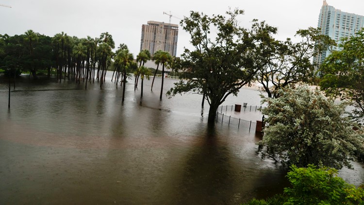
Here in the Tampa Bay area, even with the region being spared a direct hit, communities and neighborhoods saw significant flooding.
With storm surge swamping neighborhoods and busy roads, shutdowns of some bridges between Tampa and the St. Petersburg area were triggered. Access to barrier islands was temporarily shut off, and several dozen people had to be rescued from flooded homes.
Still, it could have been much worse. The storm surge in the Tampa Bay area was far lower than the levels experienced when Idalia came ashore.
The last time the region was hit by a major storm was Oct. 25, 1921, by a hurricane that had no official name but is known as the Tarpon Springs storm for the seaside town famed for its sponge-diving docks and Greek heritage.
The storm surge from that hurricane, a Category 3 with estimated winds of up to 129 mph, was 11 feet. At least eight people died, and damage was estimated at $5 million at the time.
The Associated Press contributed to this report.