TAMPA, Fla. — Hurricane Helene made landfall along Florida's Big Bend region on Thursday, Sept. 26, as a powerful Category 4 storm.
The fast-moving storm kept its momentum and stayed a hurricane all the way into central Georgia, leaving an 800-mile path of destruction across several Southeastern states even as it weakened to a tropical storm.
At least 182 people have died because of the storm, making Helene the deadliest hurricane to hit the mainland U.S. since Katrina, according to statistics from the National Hurricane Center. That includes at least 14 people who were killed in the Tampa Bay area.
What path did Helene end up taking?
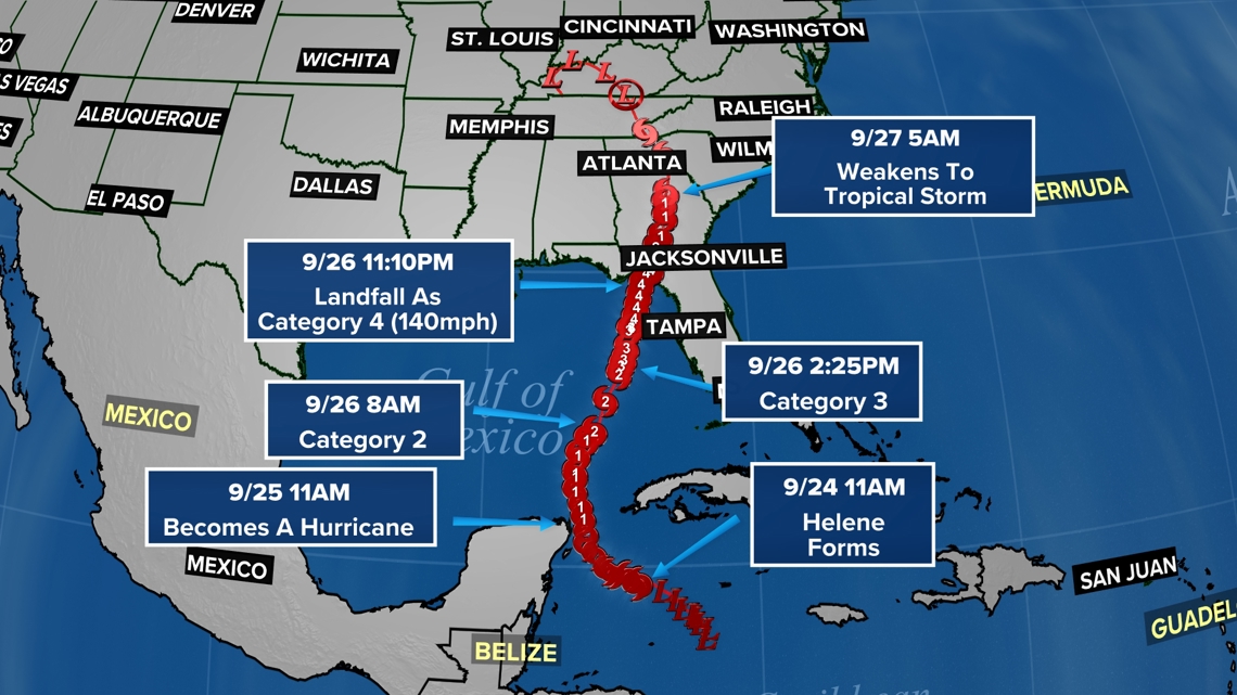
Tuesday, Sept. 24
- Tropical Storm Helene formed around 11 a.m. northeast of Belize in the Gulf of Mexico.
Wednesday, Sept, 25
- About 24 hours later, Helene strengthened into a Category 1 hurricane as it shifted slightly northwest toward Mexico.
Thursday, Sept, 26
- Around 8 a.m., Hurricane Helene strengthened into a Category 2 storm as it continued moving northeast toward Florida.
- At 2:25 p.m. Helene became a Category 3 hurricane as it brought maximum sustained winds of more than 111 miles per hour through the Gulf of Mexico just west of Tampa.
- By 11:10 p.m. Helene strengthened into a Category 4 storm with maximum sustained winds of 140 miles per hour as it made landfall near Perry in Florida's Big Bend.
Friday, Sept. 27
- Helene entered Georgia as a Category 2 hurricane with wind speeds of up to 100 miles per hour before downgrading to a tropical storm by 5 a.m.