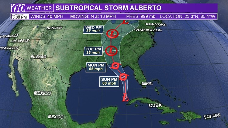
A Tropical Storm Warning has been issued for the west coast of the Florida peninsula from Bonita Beach to the Anclote River. This includes all of the coastal Tampa Bay area.
At 5 p.m. Subtropical Storm Alberto was 170 miles southwest of the Dry Tortugas. Its top winds were 40 mph as it was moving north at 13 mph.
______________________________________
What is a tropical storm warning? A Tropical Storm Warning is issued when sustained winds of 34 to 63 kt (39 to 73 mph) or higher associated with a tropical cyclone are expected in 36 hours or less. These winds may be accompanied by storm surge, coastal flooding, and/or river flooding.
______________________________________
TRACK IT: Forecast track, spaghetti models and more
A slower northward or north-northeastward motion is expected tonight, followed by a north-northwest turn on Sunday, and this general motion should continue into Tuesday.
On the forecast track, the center of Alberto is forecast to move over the eastern Gulf of Mexico tonight through Sunday night, and approach the northern Gulf Coast in the warning area on Monday.
Heavy rainfall and tropical storm conditions will likely reach the northern Gulf Coast well before the arrival of the center of Alberto.
►Make it easy to keep up-to-date with more stories like this. Download the 10 News app now.
Have a news tip? Email tips@wtsp.com, visit our Facebook page or Twitter feed.


