ST. PETERSBURG, Fla. — From warmer than normal to cooler than normal, the early-spring temperature roller coaster ride has begun.
Tuesday will bring another day with warmer than normal temperatures as highs peak in the upper 70s and low 80s once again this afternoon.
Meanwhile, an area of low pressure moving out of the Central Plains is spreading precipitation across the Deep South into the Mid-Atlantic. Even a few showers have spread south into the northern part of the Florida Peninsula.
The main area of low pressure will track to the northeast, but the associated cold front will continue to sweep east and eventually move through Tampa Bay by Wednesday night.
Scattered showers and storms will continue to form out ahead of the cold front as warm and moist conditions surge in from the south. The chance of a few pop-up showers will begin to increase through this afternoon and evening, but the best chance of rain won't arrive until the cold front gets closer by Wednesday morning.
In addition to the warm temperatures on Tuesday in Tampa Bay, it'll also be a little breezy and muggy as the moisture increases out of the south ahead of the approaching cold front. Winds in Tampa Bay through Tuesday will be out of the south from 10-15 mph, gusting as high as 25 mph at times.
By Tuesday night, into Wednesday morning the chance of rain will increase to around 80 percent as widespread showers are expected to form immediately ahead of the approaching front. Meanwhile, temperatures on Wednesday will be in the middle 70s under mostly cloudy skies.
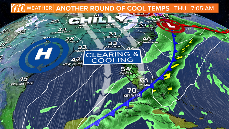
The cold front will push south of Tampa Bay overnight Wednesday into Thursday morning when cooler and drier air will begin to rush in from the north. Conditions will be sunny, but cool and breezy Thursday afternoon as temperatures struggle to climb into the low 60s.
WTSP meteorologists on Facebook: Bobby Deskins, Grant Gilmore, Ric Kearbey, Natalie Ferrari, Autumn Robertson
WTSP meteorologists on Twitter: Bobby Deskins, Grant Gilmore, Ric Kearbey, Natalie Ferrari, Autumn Robertson
Cooler air will continue to funnel in from the north overnight Thursday into Friday morning, dropping temperatures into the low-middle 40s.
Another re-enforcing push of cool air will arrive with a fast-moving and relatively dry system Saturday night. This will keep low temperatures in the 40s with highs in the low-middle 60s through the weekend into the beginning of next week. The Nature Coast should expect temperatures in the mid-upper 30s through the weekend.
The normal high and low temperatures this time of year in Tampa Bay is 72° and 52°. While temperatures later this week will be cooler than normal they are not expected to break any records.
What other people are reading right now:
- 'They will run them': Neighbors look for changes at flashing crosswalks after injuries
- She thought it was a SunPass error-- it wasn't. Turn To 10 helped solve the problem
- Kobe, Gianna Bryant honored with public memorial Monday
- Custom casket made for Utah police K-9 killed in line of duty
- Skyway 10K guide: Everything you need to know to race
FREE 10NEWS APP: